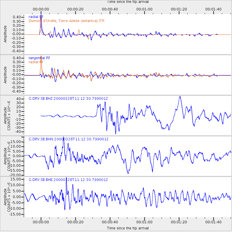
DRV Dumont d'Urville, Terre Adelie (Antartica) - Earthquake Result Viewer
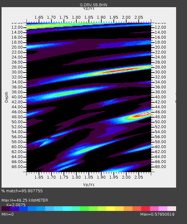
Earthquake location: Volcano Islands, Japan Region
Earthquake latitude/longitude: 22.3/143.7
Earthquake time(UTC): 2000/03/28 (088) 11:00:22 GMT
Earthquake Depth: 126 km
Earthquake Magnitude: 6.8 MB, 7.6 MS, 7.6 MW, 7.6 MW
Earthquake Catalog/Contributor: WHDF/NEIC
Network: G GEOSCOPE
Station: DRV Dumont d'Urville, Terre Adelie (Antartica)
Lat/Lon: 66.67 S/140.01 E
Elevation: 40 m
Distance: 88.8 deg
Az: 181.481 deg
Baz: 3.445 deg
Ray Param: 0.042068876
Estimated Moho Depth: 46.25 km
Estimated Crust Vp/Vs: 2.09
Assumed Crust Vp: 6.39 km/s
Estimated Crust Vs: 3.061 km/s
Estimated Crust Poisson's Ratio: 0.35
Radial Match: 95.987755 %
Radial Bump: 400
Transverse Match: 86.051056 %
Transverse Bump: 400
SOD ConfigId: 3744
Insert Time: 2010-02-26 22:06:19.819 +0000
GWidth: 2.5
Max Bumps: 400
Tol: 0.001

Signal To Noise

ChannelStoNSTALTA
G:DRV:SB:BHN:20000328T11:12:30.799001Z5.4216135.314693E-69.80279E-7
G:DRV:SB:BHE:20000328T11:12:30.799001Z1.0664271.5979788E-61.4984419E-6
G:DRV:SB:BHZ:20000328T11:12:30.799001Z9.5806111.4602421E-51.5241638E-6
Arrivals
Ps8.0 SECOND
PpPs22 SECOND
PsPs/PpSs30 SECOND