You are here: Home > Network List > CI - Caltech Regional Seismic Network Stations List
> Station ADO Adelanto Receiving Station, Victorville, CA, USA > Earthquake Result Viewer
ADO Adelanto Receiving Station, Victorville, CA, USA - Earthquake Result Viewer
| Earthquake location: |
Fiji Islands Region |
| Earthquake latitude/longitude: |
-16.5/-177.0 |
| Earthquake time(UTC): |
2011/08/19 (231) 03:54:26 GMT |
| Earthquake Depth: |
408 km |
| Earthquake Magnitude: |
5.5 MB, 6.2 MW, 6.2 MW |
| Earthquake Catalog/Contributor: |
WHDF/NEIC |
|
| Network: |
CI Caltech Regional Seismic Network |
| Station: |
ADO Adelanto Receiving Station, Victorville, CA, USA |
| Lat/Lon: |
34.55 N/117.43 W |
| Elevation: |
908 m |
|
| Distance: |
76.0 deg |
| Az: |
47.172 deg |
| Baz: |
238.464 deg |
| Ray Param: |
0.050081264 |
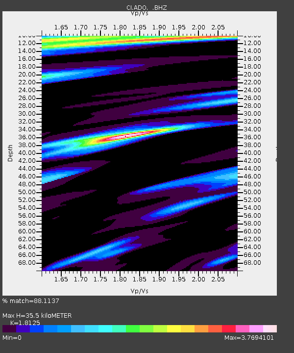
| Estimated Moho Depth: |
35.5 km |
| Estimated Crust Vp/Vs: |
1.81 |
| Assumed Crust Vp: |
6.276 km/s |
| Estimated Crust Vs: |
3.463 km/s |
| Estimated Crust Poisson's Ratio: |
0.28 |
|
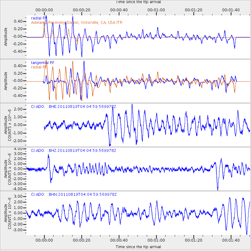
| Radial Match: |
88.1137 % |
| Radial Bump: |
288 |
| Transverse Match: |
75.70266 % |
| Transverse Bump: |
276 |
| SOD ConfigId: |
410809 |
| Insert Time: |
2012-01-06 07:45:28.622 +0000 |
| GWidth: |
2.5 |
| Max Bumps: |
400 |
| Tol: |
0.001 |
|
Signal To Noise
| Channel | StoN | STA | LTA |
| CI:ADO: :BHZ:20110819T04:04:59.569978Z | 5.8309164 | 1.34428E-6 | 2.305435E-7 |
| CI:ADO: :BHN:20110819T04:04:59.569978Z | 0.7812149 | 2.9509602E-7 | 3.7773987E-7 |
| CI:ADO: :BHE:20110819T04:04:59.569978Z | 2.7387247 | 7.42959E-7 | 2.712792E-7 |
| Arrivals |
| Ps | 4.7 SECOND |
| PpPs | 15 SECOND |
| PsPs/PpSs | 20 SECOND |


