You are here: Home > Network List > G - GEOSCOPE Stations List
> Station DRV Dumont d'Urville, Terre Adelie (Antartica) > Earthquake Result Viewer
DRV Dumont d'Urville, Terre Adelie (Antartica) - Earthquake Result Viewer
| Earthquake location: |
Kermadec Islands Region |
| Earthquake latitude/longitude: |
-31.9/-179.0 |
| Earthquake time(UTC): |
1999/04/20 (110) 19:04:08 GMT |
| Earthquake Depth: |
96 km |
| Earthquake Magnitude: |
6.2 MB, 6.5 MW, 6.5 MW |
| Earthquake Catalog/Contributor: |
WHDF/NEIC |
|
| Network: |
G GEOSCOPE |
| Station: |
DRV Dumont d'Urville, Terre Adelie (Antartica) |
| Lat/Lon: |
66.67 S/140.01 E |
| Elevation: |
40 m |
|
| Distance: |
42.4 deg |
| Az: |
202.767 deg |
| Baz: |
55.729 deg |
| Ray Param: |
0.07286489 |
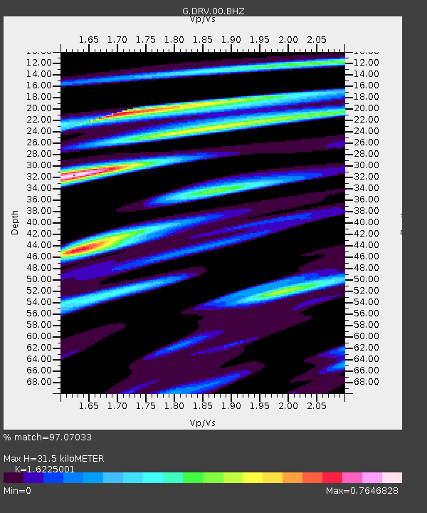
| Estimated Moho Depth: |
31.5 km |
| Estimated Crust Vp/Vs: |
1.62 |
| Assumed Crust Vp: |
6.39 km/s |
| Estimated Crust Vs: |
3.938 km/s |
| Estimated Crust Poisson's Ratio: |
0.19 |
|
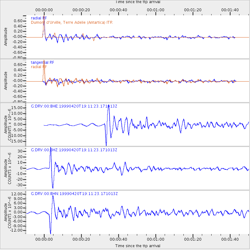
| Radial Match: |
97.07033 % |
| Radial Bump: |
265 |
| Transverse Match: |
85.24604 % |
| Transverse Bump: |
400 |
| SOD ConfigId: |
4480 |
| Insert Time: |
2010-02-26 22:06:37.224 +0000 |
| GWidth: |
2.5 |
| Max Bumps: |
400 |
| Tol: |
0.001 |
|
Signal To Noise
| Channel | StoN | STA | LTA |
| G:DRV:00:BHZ:19990420T19:11:23.171013Z | 16.355507 | 1.5738015E-5 | 9.622456E-7 |
| G:DRV:00:BHN:19990420T19:11:23.171013Z | 14.741269 | 5.5559813E-6 | 3.768998E-7 |
| G:DRV:00:BHE:19990420T19:11:23.171013Z | 15.725842 | 8.086521E-6 | 5.1421864E-7 |
| Arrivals |
| Ps | 3.3 SECOND |
| PpPs | 12 SECOND |
| PsPs/PpSs | 15 SECOND |


