You are here: Home > Network List > TA - USArray Transportable Network (new EarthScope stations) Stations List
> Station MSTX Muleshoe, TX, USA > Earthquake Result Viewer
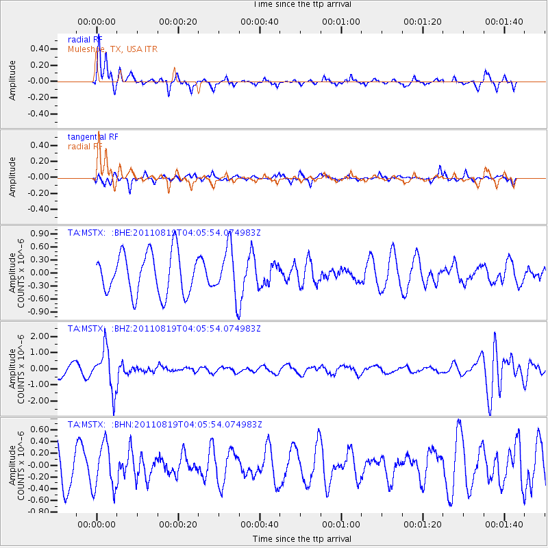
MSTX Muleshoe, TX, USA - Earthquake Result Viewer
*The percent match for this event was below the threshold and hence no stack was calculated.
| Earthquake location: |
Fiji Islands Region |
| Earthquake latitude/longitude: |
-16.5/-177.0 |
| Earthquake time(UTC): |
2011/08/19 (231) 03:54:26 GMT |
| Earthquake Depth: |
408 km |
| Earthquake Magnitude: |
5.5 MB, 6.2 MW, 6.2 MW |
| Earthquake Catalog/Contributor: |
WHDF/NEIC |
|
| Network: |
TA USArray Transportable Network (new EarthScope stations) |
| Station: |
MSTX Muleshoe, TX, USA |
| Lat/Lon: |
33.97 N/102.77 W |
| Elevation: |
1167 m |
|
| Distance: |
86.6 deg |
| Az: |
53.246 deg |
| Baz: |
247.633 deg |
| Ray Param: |
$rayparam |
*The percent match for this event was below the threshold and hence was not used in the summary stack. |
|
| Radial Match: |
68.94758 % |
| Radial Bump: |
286 |
| Transverse Match: |
65.64229 % |
| Transverse Bump: |
280 |
| SOD ConfigId: |
410809 |
| Insert Time: |
2012-01-06 07:53:25.080 +0000 |
| GWidth: |
2.5 |
| Max Bumps: |
400 |
| Tol: |
0.001 |
|
Signal To Noise
| Channel | StoN | STA | LTA |
| TA:MSTX: :BHZ:20110819T04:05:54.074983Z | 2.7449956 | 1.3125392E-6 | 4.781571E-7 |
| TA:MSTX: :BHN:20110819T04:05:54.074983Z | 0.8039997 | 3.8730084E-7 | 4.817177E-7 |
| TA:MSTX: :BHE:20110819T04:05:54.074983Z | 1.2135082 | 5.756629E-7 | 4.743791E-7 |
| Arrivals |
| Ps | |
| PpPs | |
| PsPs/PpSs | |


