You are here: Home > Network List > TA - USArray Transportable Network (new EarthScope stations) Stations List
> Station X34A Smith Ranch, Marlow, OK, USA > Earthquake Result Viewer
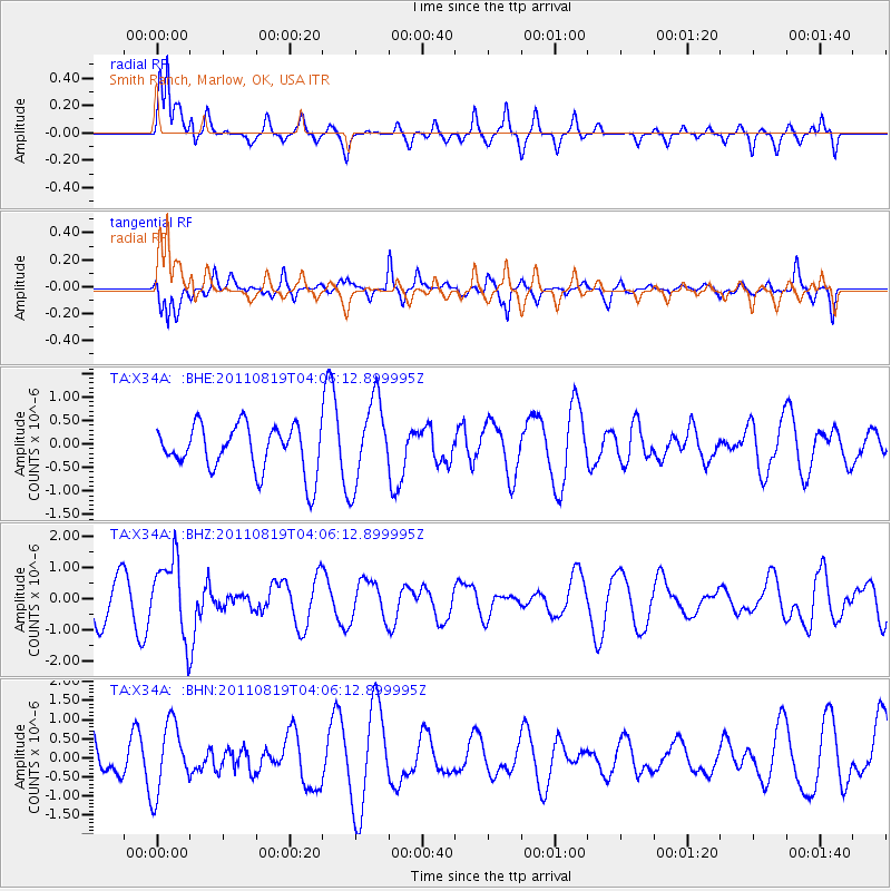
X34A Smith Ranch, Marlow, OK, USA - Earthquake Result Viewer
*The percent match for this event was below the threshold and hence no stack was calculated.
| Earthquake location: |
Fiji Islands Region |
| Earthquake latitude/longitude: |
-16.5/-177.0 |
| Earthquake time(UTC): |
2011/08/19 (231) 03:54:26 GMT |
| Earthquake Depth: |
408 km |
| Earthquake Magnitude: |
5.5 MB, 6.2 MW, 6.2 MW |
| Earthquake Catalog/Contributor: |
WHDF/NEIC |
|
| Network: |
TA USArray Transportable Network (new EarthScope stations) |
| Station: |
X34A Smith Ranch, Marlow, OK, USA |
| Lat/Lon: |
34.60 N/97.83 W |
| Elevation: |
364 m |
|
| Distance: |
90.6 deg |
| Az: |
54.122 deg |
| Baz: |
250.425 deg |
| Ray Param: |
$rayparam |
*The percent match for this event was below the threshold and hence was not used in the summary stack. |
|
| Radial Match: |
79.98217 % |
| Radial Bump: |
341 |
| Transverse Match: |
63.545918 % |
| Transverse Bump: |
398 |
| SOD ConfigId: |
410809 |
| Insert Time: |
2012-01-06 07:57:59.582 +0000 |
| GWidth: |
2.5 |
| Max Bumps: |
400 |
| Tol: |
0.001 |
|
Signal To Noise
| Channel | StoN | STA | LTA |
| TA:X34A: :BHZ:20110819T04:06:12.899995Z | 1.4466535 | 1.2250082E-6 | 8.4678754E-7 |
| TA:X34A: :BHN:20110819T04:06:12.899995Z | 2.0766976 | 9.095929E-7 | 4.3799972E-7 |
| TA:X34A: :BHE:20110819T04:06:12.899995Z | 1.8301755 | 8.916463E-7 | 4.871917E-7 |
| Arrivals |
| Ps | |
| PpPs | |
| PsPs/PpSs | |


