You are here: Home > Network List > TA - USArray Transportable Network (new EarthScope stations) Stations List
> Station L02D Cave Junction, OR, USA > Earthquake Result Viewer
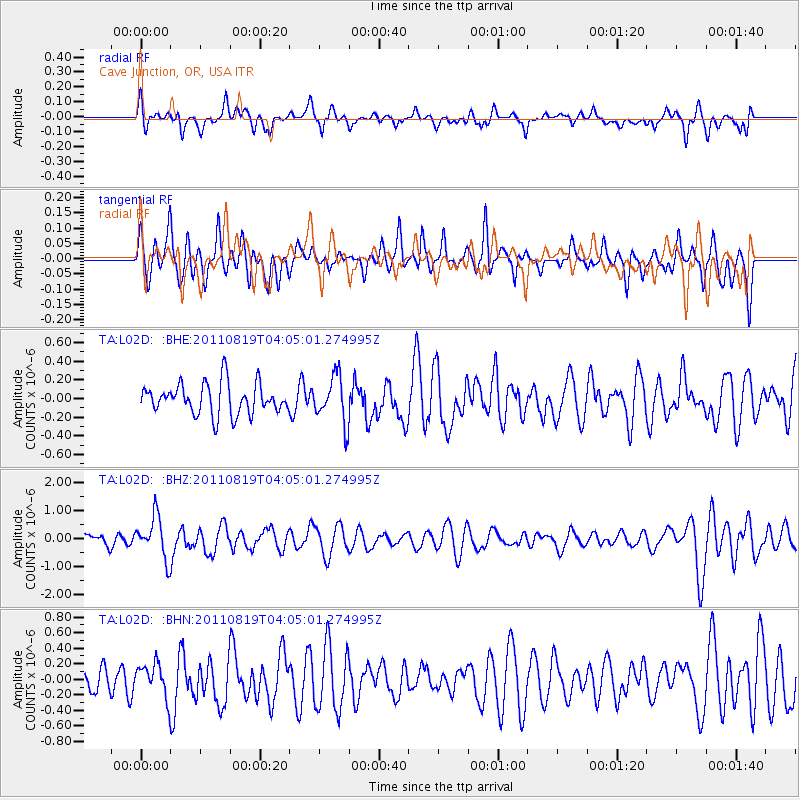
L02D Cave Junction, OR, USA - Earthquake Result Viewer
*The percent match for this event was below the threshold and hence no stack was calculated.
| Earthquake location: |
Fiji Islands Region |
| Earthquake latitude/longitude: |
-16.5/-177.0 |
| Earthquake time(UTC): |
2011/08/19 (231) 03:54:26 GMT |
| Earthquake Depth: |
408 km |
| Earthquake Magnitude: |
5.5 MB, 6.2 MW, 6.2 MW |
| Earthquake Catalog/Contributor: |
WHDF/NEIC |
|
| Network: |
TA USArray Transportable Network (new EarthScope stations) |
| Station: |
L02D Cave Junction, OR, USA |
| Lat/Lon: |
42.16 N/123.60 W |
| Elevation: |
458 m |
|
| Distance: |
76.3 deg |
| Az: |
37.903 deg |
| Baz: |
232.422 deg |
| Ray Param: |
$rayparam |
*The percent match for this event was below the threshold and hence was not used in the summary stack. |
|
| Radial Match: |
61.72624 % |
| Radial Bump: |
400 |
| Transverse Match: |
58.218395 % |
| Transverse Bump: |
400 |
| SOD ConfigId: |
410809 |
| Insert Time: |
2012-01-06 07:58:57.976 +0000 |
| GWidth: |
2.5 |
| Max Bumps: |
400 |
| Tol: |
0.001 |
|
Signal To Noise
| Channel | StoN | STA | LTA |
| TA:L02D: :BHZ:20110819T04:05:01.274995Z | 3.8355174 | 7.4920877E-7 | 1.9533448E-7 |
| TA:L02D: :BHN:20110819T04:05:01.274995Z | 1.1344912 | 2.0967109E-7 | 1.848151E-7 |
| TA:L02D: :BHE:20110819T04:05:01.274995Z | 1.5169611 | 2.49318E-7 | 1.6435358E-7 |
| Arrivals |
| Ps | |
| PpPs | |
| PsPs/PpSs | |


