You are here: Home > Network List > TA - USArray Transportable Network (new EarthScope stations) Stations List
> Station Z34A Collier Ranch, Chico, TX, USA > Earthquake Result Viewer
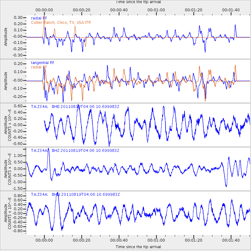
Z34A Collier Ranch, Chico, TX, USA - Earthquake Result Viewer
*The percent match for this event was below the threshold and hence no stack was calculated.
| Earthquake location: |
Fiji Islands Region |
| Earthquake latitude/longitude: |
-16.5/-177.0 |
| Earthquake time(UTC): |
2011/08/19 (231) 03:54:26 GMT |
| Earthquake Depth: |
408 km |
| Earthquake Magnitude: |
5.5 MB, 6.2 MW, 6.2 MW |
| Earthquake Catalog/Contributor: |
WHDF/NEIC |
|
| Network: |
TA USArray Transportable Network (new EarthScope stations) |
| Station: |
Z34A Collier Ranch, Chico, TX, USA |
| Lat/Lon: |
33.37 N/97.92 W |
| Elevation: |
341 m |
|
| Distance: |
90.2 deg |
| Az: |
55.254 deg |
| Baz: |
250.371 deg |
| Ray Param: |
$rayparam |
*The percent match for this event was below the threshold and hence was not used in the summary stack. |
|
| Radial Match: |
53.64802 % |
| Radial Bump: |
283 |
| Transverse Match: |
46.475277 % |
| Transverse Bump: |
304 |
| SOD ConfigId: |
410809 |
| Insert Time: |
2012-01-06 07:59:08.533 +0000 |
| GWidth: |
2.5 |
| Max Bumps: |
400 |
| Tol: |
0.001 |
|
Signal To Noise
| Channel | StoN | STA | LTA |
| TA:Z34A: :BHZ:20110819T04:06:10.699983Z | 2.3424459 | 6.744146E-7 | 2.8791044E-7 |
| TA:Z34A: :BHN:20110819T04:06:10.699983Z | 1.2164485 | 4.0839208E-7 | 3.357249E-7 |
| TA:Z34A: :BHE:20110819T04:06:10.699983Z | 1.1003861 | 3.1602744E-7 | 2.8719685E-7 |
| Arrivals |
| Ps | |
| PpPs | |
| PsPs/PpSs | |


