You are here: Home > Network List > TA - USArray Transportable Network (new EarthScope stations) Stations List
> Station E62A Clayton Lake, ME, USA > Earthquake Result Viewer
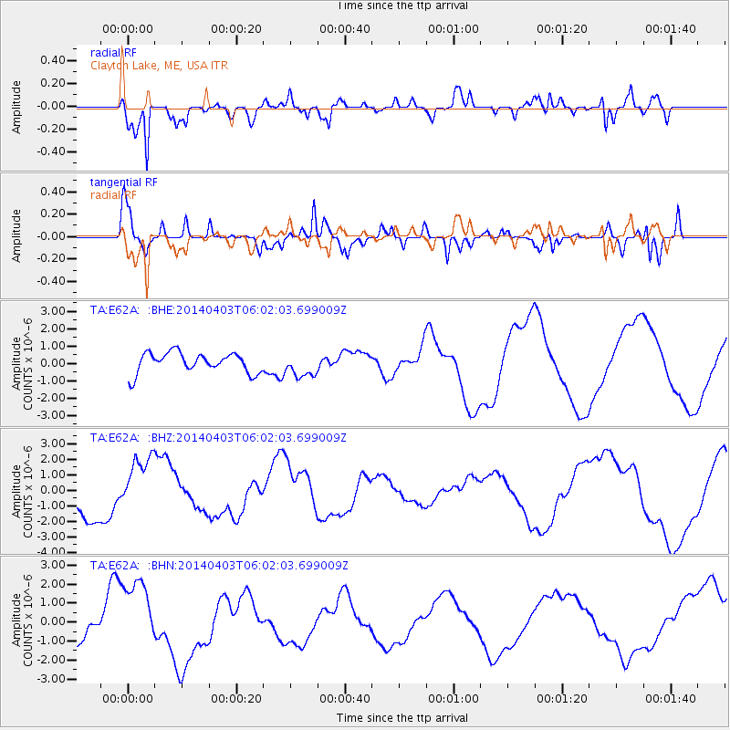
E62A Clayton Lake, ME, USA - Earthquake Result Viewer
*The percent match for this event was below the threshold and hence no stack was calculated.
| Earthquake location: |
Near Coast Of Northern Chile |
| Earthquake latitude/longitude: |
-20.8/-70.4 |
| Earthquake time(UTC): |
2014/04/03 (093) 05:51:44 GMT |
| Earthquake Depth: |
27 km |
| Earthquake Magnitude: |
5.5 MB, 5.3 MWR |
| Earthquake Catalog/Contributor: |
NEIC PDE/NEIC COMCAT |
|
| Network: |
TA USArray Transportable Network (new EarthScope stations) |
| Station: |
E62A Clayton Lake, ME, USA |
| Lat/Lon: |
46.62 N/69.52 W |
| Elevation: |
356 m |
|
| Distance: |
67.1 deg |
| Az: |
0.657 deg |
| Baz: |
180.892 deg |
| Ray Param: |
$rayparam |
*The percent match for this event was below the threshold and hence was not used in the summary stack. |
|
| Radial Match: |
80.969246 % |
| Radial Bump: |
400 |
| Transverse Match: |
57.01321 % |
| Transverse Bump: |
400 |
| SOD ConfigId: |
3390531 |
| Insert Time: |
2019-04-11 02:59:51.691 +0000 |
| GWidth: |
2.5 |
| Max Bumps: |
400 |
| Tol: |
0.001 |
|
Signal To Noise
| Channel | StoN | STA | LTA |
| TA:E62A: :BHZ:20140403T06:02:03.699009Z | 1.4399344 | 1.758864E-6 | 1.221489E-6 |
| TA:E62A: :BHN:20140403T06:02:03.699009Z | 2.9471476 | 2.0950154E-6 | 7.10862E-7 |
| TA:E62A: :BHE:20140403T06:02:03.699009Z | 1.3813684 | 7.2493856E-7 | 5.2479743E-7 |
| Arrivals |
| Ps | |
| PpPs | |
| PsPs/PpSs | |


