You are here: Home > Network List > TA - USArray Transportable Network (new EarthScope stations) Stations List
> Station 334A Lometa, TX, USA > Earthquake Result Viewer
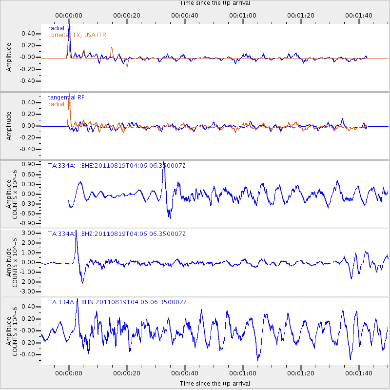
334A Lometa, TX, USA - Earthquake Result Viewer
*The percent match for this event was below the threshold and hence no stack was calculated.
| Earthquake location: |
Fiji Islands Region |
| Earthquake latitude/longitude: |
-16.5/-177.0 |
| Earthquake time(UTC): |
2011/08/19 (231) 03:54:26 GMT |
| Earthquake Depth: |
408 km |
| Earthquake Magnitude: |
5.5 MB, 6.2 MW, 6.2 MW |
| Earthquake Catalog/Contributor: |
WHDF/NEIC |
|
| Network: |
TA USArray Transportable Network (new EarthScope stations) |
| Station: |
334A Lometa, TX, USA |
| Lat/Lon: |
31.33 N/98.24 W |
| Elevation: |
389 m |
|
| Distance: |
89.2 deg |
| Az: |
57.076 deg |
| Baz: |
250.21 deg |
| Ray Param: |
$rayparam |
*The percent match for this event was below the threshold and hence was not used in the summary stack. |
|
| Radial Match: |
75.59436 % |
| Radial Bump: |
400 |
| Transverse Match: |
71.21357 % |
| Transverse Bump: |
400 |
| SOD ConfigId: |
410809 |
| Insert Time: |
2012-01-06 07:59:35.477 +0000 |
| GWidth: |
2.5 |
| Max Bumps: |
400 |
| Tol: |
0.001 |
|
Signal To Noise
| Channel | StoN | STA | LTA |
| TA:334A: :BHZ:20110819T04:06:06.350007Z | 8.80443 | 1.2136993E-6 | 1.3785099E-7 |
| TA:334A: :BHN:20110819T04:06:06.350007Z | 1.8542995 | 1.9398101E-7 | 1.0461148E-7 |
| TA:334A: :BHE:20110819T04:06:06.350007Z | 2.905982 | 4.2471098E-7 | 1.4615058E-7 |
| Arrivals |
| Ps | |
| PpPs | |
| PsPs/PpSs | |


