You are here: Home > Network List > TA - USArray Transportable Network (new EarthScope stations) Stations List
> Station 337A Centerville, TX, USA > Earthquake Result Viewer
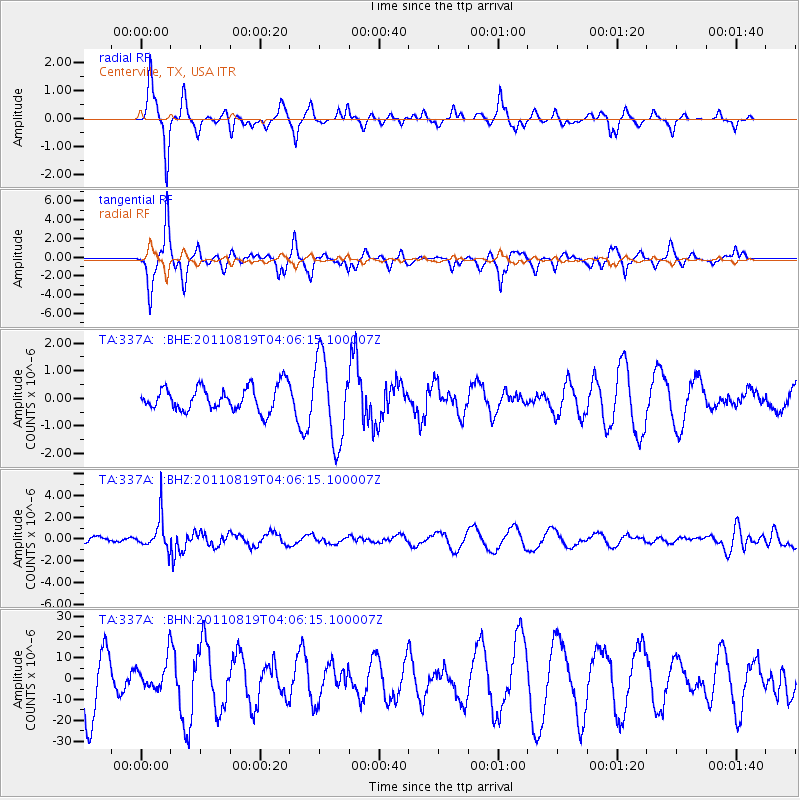
337A Centerville, TX, USA - Earthquake Result Viewer
*The percent match for this event was below the threshold and hence no stack was calculated.
| Earthquake location: |
Fiji Islands Region |
| Earthquake latitude/longitude: |
-16.5/-177.0 |
| Earthquake time(UTC): |
2011/08/19 (231) 03:54:26 GMT |
| Earthquake Depth: |
408 km |
| Earthquake Magnitude: |
5.5 MB, 6.2 MW, 6.2 MW |
| Earthquake Catalog/Contributor: |
WHDF/NEIC |
|
| Network: |
TA USArray Transportable Network (new EarthScope stations) |
| Station: |
337A Centerville, TX, USA |
| Lat/Lon: |
31.32 N/95.89 W |
| Elevation: |
150 m |
|
| Distance: |
91.1 deg |
| Az: |
57.753 deg |
| Baz: |
251.425 deg |
| Ray Param: |
$rayparam |
*The percent match for this event was below the threshold and hence was not used in the summary stack. |
|
| Radial Match: |
65.57068 % |
| Radial Bump: |
248 |
| Transverse Match: |
66.487526 % |
| Transverse Bump: |
273 |
| SOD ConfigId: |
410809 |
| Insert Time: |
2012-01-06 08:02:33.685 +0000 |
| GWidth: |
2.5 |
| Max Bumps: |
400 |
| Tol: |
0.001 |
|
Signal To Noise
| Channel | StoN | STA | LTA |
| TA:337A: :BHZ:20110819T04:06:15.100007Z | 4.183579 | 1.5046971E-6 | 3.5966744E-7 |
| TA:337A: :BHN:20110819T04:06:15.100007Z | 0.46387473 | 7.066039E-6 | 1.5232646E-5 |
| TA:337A: :BHE:20110819T04:06:15.100007Z | 3.5110633 | 1.5268025E-6 | 4.3485474E-7 |
| Arrivals |
| Ps | |
| PpPs | |
| PsPs/PpSs | |


