You are here: Home > Network List > TA - USArray Transportable Network (new EarthScope stations) Stations List
> Station S34A Willow Spring Farm, Andover, KS, USA > Earthquake Result Viewer
S34A Willow Spring Farm, Andover, KS, USA - Earthquake Result Viewer
| Earthquake location: |
Fiji Islands Region |
| Earthquake latitude/longitude: |
-16.5/-177.0 |
| Earthquake time(UTC): |
2011/08/19 (231) 03:54:26 GMT |
| Earthquake Depth: |
408 km |
| Earthquake Magnitude: |
5.5 MB, 6.2 MW, 6.2 MW |
| Earthquake Catalog/Contributor: |
WHDF/NEIC |
|
| Network: |
TA USArray Transportable Network (new EarthScope stations) |
| Station: |
S34A Willow Spring Farm, Andover, KS, USA |
| Lat/Lon: |
37.70 N/97.11 W |
| Elevation: |
373 m |
|
| Distance: |
92.2 deg |
| Az: |
51.395 deg |
| Baz: |
250.917 deg |
| Ray Param: |
0.041226264 |
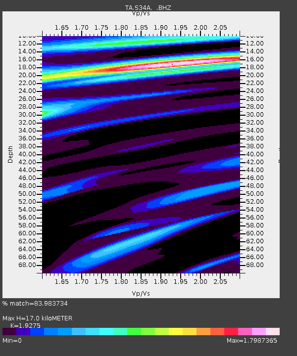
| Estimated Moho Depth: |
17.0 km |
| Estimated Crust Vp/Vs: |
1.93 |
| Assumed Crust Vp: |
6.483 km/s |
| Estimated Crust Vs: |
3.363 km/s |
| Estimated Crust Poisson's Ratio: |
0.32 |
|
| Radial Match: |
83.983734 % |
| Radial Bump: |
400 |
| Transverse Match: |
76.47832 % |
| Transverse Bump: |
400 |
| SOD ConfigId: |
410809 |
| Insert Time: |
2012-01-06 08:04:07.792 +0000 |
| GWidth: |
2.5 |
| Max Bumps: |
400 |
| Tol: |
0.001 |
|

Signal To Noise
| Channel | StoN | STA | LTA |
| TA:S34A: :BHZ:20110819T04:06:20.124971Z | 1.9953655 | 7.4558324E-7 | 3.7365749E-7 |
| TA:S34A: :BHN:20110819T04:06:20.124971Z | 2.1235573 | 5.509403E-7 | 2.5944217E-7 |
| TA:S34A: :BHE:20110819T04:06:20.124971Z | 0.760512 | 3.1138384E-7 | 4.0943976E-7 |
| Arrivals |
| Ps | 2.5 SECOND |
| PpPs | 7.5 SECOND |
| PsPs/PpSs | 10 SECOND |


