You are here: Home > Network List > TA - USArray Transportable Network (new EarthScope stations) Stations List
> Station Q37A Longview Farm, Lee's Summit, MO, USA > Earthquake Result Viewer
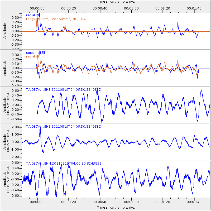
Q37A Longview Farm, Lee's Summit, MO, USA - Earthquake Result Viewer
*The percent match for this event was below the threshold and hence no stack was calculated.
| Earthquake location: |
Fiji Islands Region |
| Earthquake latitude/longitude: |
-16.5/-177.0 |
| Earthquake time(UTC): |
2011/08/19 (231) 03:54:26 GMT |
| Earthquake Depth: |
408 km |
| Earthquake Magnitude: |
5.5 MB, 6.2 MW, 6.2 MW |
| Earthquake Catalog/Contributor: |
WHDF/NEIC |
|
| Network: |
TA USArray Transportable Network (new EarthScope stations) |
| Station: |
Q37A Longview Farm, Lee's Summit, MO, USA |
| Lat/Lon: |
38.88 N/94.45 W |
| Elevation: |
297 m |
|
| Distance: |
94.6 deg |
| Az: |
50.935 deg |
| Baz: |
252.585 deg |
| Ray Param: |
$rayparam |
*The percent match for this event was below the threshold and hence was not used in the summary stack. |
|
| Radial Match: |
82.94671 % |
| Radial Bump: |
400 |
| Transverse Match: |
55.699562 % |
| Transverse Bump: |
400 |
| SOD ConfigId: |
410809 |
| Insert Time: |
2012-01-06 08:04:12.073 +0000 |
| GWidth: |
2.5 |
| Max Bumps: |
400 |
| Tol: |
0.001 |
|
Signal To Noise
| Channel | StoN | STA | LTA |
| TA:Q37A: :BHZ:20110819T04:06:30.824983Z | 3.356973 | 9.2098827E-7 | 2.743508E-7 |
| TA:Q37A: :BHN:20110819T04:06:30.824983Z | 1.5323607 | 3.5288164E-7 | 2.302863E-7 |
| TA:Q37A: :BHE:20110819T04:06:30.824983Z | 1.0092931 | 2.66648E-7 | 2.641928E-7 |
| Arrivals |
| Ps | |
| PpPs | |
| PsPs/PpSs | |


