You are here: Home > Network List > TA - USArray Transportable Network (new EarthScope stations) Stations List
> Station N35A Tabor, IA, USA > Earthquake Result Viewer
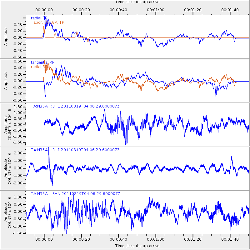
N35A Tabor, IA, USA - Earthquake Result Viewer
*The percent match for this event was below the threshold and hence no stack was calculated.
| Earthquake location: |
Fiji Islands Region |
| Earthquake latitude/longitude: |
-16.5/-177.0 |
| Earthquake time(UTC): |
2011/08/19 (231) 03:54:26 GMT |
| Earthquake Depth: |
408 km |
| Earthquake Magnitude: |
5.5 MB, 6.2 MW, 6.2 MW |
| Earthquake Catalog/Contributor: |
WHDF/NEIC |
|
| Network: |
TA USArray Transportable Network (new EarthScope stations) |
| Station: |
N35A Tabor, IA, USA |
| Lat/Lon: |
40.86 N/95.64 W |
| Elevation: |
353 m |
|
| Distance: |
94.3 deg |
| Az: |
48.762 deg |
| Baz: |
251.993 deg |
| Ray Param: |
$rayparam |
*The percent match for this event was below the threshold and hence was not used in the summary stack. |
|
| Radial Match: |
51.298637 % |
| Radial Bump: |
400 |
| Transverse Match: |
53.526867 % |
| Transverse Bump: |
400 |
| SOD ConfigId: |
410809 |
| Insert Time: |
2012-01-06 08:07:27.643 +0000 |
| GWidth: |
2.5 |
| Max Bumps: |
400 |
| Tol: |
0.001 |
|
Signal To Noise
| Channel | StoN | STA | LTA |
| TA:N35A: :BHZ:20110819T04:06:29.600007Z | 2.5785522 | 9.952852E-7 | 3.8598608E-7 |
| TA:N35A: :BHN:20110819T04:06:29.600007Z | 1.5719726 | 5.072339E-7 | 3.226735E-7 |
| TA:N35A: :BHE:20110819T04:06:29.600007Z | 1.7119386 | 5.714231E-7 | 3.337871E-7 |
| Arrivals |
| Ps | |
| PpPs | |
| PsPs/PpSs | |


