You are here: Home > Network List > TA - USArray Transportable Network (new EarthScope stations) Stations List
> Station L04D Klamath Falls, OR, USA > Earthquake Result Viewer
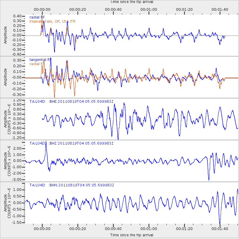
L04D Klamath Falls, OR, USA - Earthquake Result Viewer
*The percent match for this event was below the threshold and hence no stack was calculated.
| Earthquake location: |
Fiji Islands Region |
| Earthquake latitude/longitude: |
-16.5/-177.0 |
| Earthquake time(UTC): |
2011/08/19 (231) 03:54:26 GMT |
| Earthquake Depth: |
408 km |
| Earthquake Magnitude: |
5.5 MB, 6.2 MW, 6.2 MW |
| Earthquake Catalog/Contributor: |
WHDF/NEIC |
|
| Network: |
TA USArray Transportable Network (new EarthScope stations) |
| Station: |
L04D Klamath Falls, OR, USA |
| Lat/Lon: |
42.22 N/122.30 W |
| Elevation: |
1437 m |
|
| Distance: |
77.1 deg |
| Az: |
38.451 deg |
| Baz: |
233.417 deg |
| Ray Param: |
$rayparam |
*The percent match for this event was below the threshold and hence was not used in the summary stack. |
|
| Radial Match: |
64.44215 % |
| Radial Bump: |
341 |
| Transverse Match: |
59.537178 % |
| Transverse Bump: |
319 |
| SOD ConfigId: |
410809 |
| Insert Time: |
2012-01-06 08:17:59.753 +0000 |
| GWidth: |
2.5 |
| Max Bumps: |
400 |
| Tol: |
0.001 |
|
Signal To Noise
| Channel | StoN | STA | LTA |
| TA:L04D: :BHZ:20110819T04:05:05.699983Z | 6.3005905 | 1.1657881E-6 | 1.850284E-7 |
| TA:L04D: :BHN:20110819T04:05:05.699983Z | 1.089779 | 1.758855E-7 | 1.6139556E-7 |
| TA:L04D: :BHE:20110819T04:05:05.699983Z | 1.4088724 | 2.7400023E-7 | 1.9448194E-7 |
| Arrivals |
| Ps | |
| PpPs | |
| PsPs/PpSs | |


