You are here: Home > Network List > TA - USArray Transportable Network (new EarthScope stations) Stations List
> Station J31A Geddes, SD, USA > Earthquake Result Viewer
J31A Geddes, SD, USA - Earthquake Result Viewer
| Earthquake location: |
Fiji Islands Region |
| Earthquake latitude/longitude: |
-16.5/-177.0 |
| Earthquake time(UTC): |
2011/08/19 (231) 03:54:26 GMT |
| Earthquake Depth: |
408 km |
| Earthquake Magnitude: |
5.5 MB, 6.2 MW, 6.2 MW |
| Earthquake Catalog/Contributor: |
WHDF/NEIC |
|
| Network: |
TA USArray Transportable Network (new EarthScope stations) |
| Station: |
J31A Geddes, SD, USA |
| Lat/Lon: |
43.29 N/98.74 W |
| Elevation: |
491 m |
|
| Distance: |
92.9 deg |
| Az: |
45.711 deg |
| Baz: |
250.116 deg |
| Ray Param: |
0.041076213 |
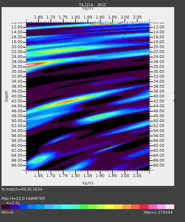
| Estimated Moho Depth: |
10.0 km |
| Estimated Crust Vp/Vs: |
2.01 |
| Assumed Crust Vp: |
6.53 km/s |
| Estimated Crust Vs: |
3.249 km/s |
| Estimated Crust Poisson's Ratio: |
0.34 |
|
| Radial Match: |
85.912834 % |
| Radial Bump: |
400 |
| Transverse Match: |
48.329094 % |
| Transverse Bump: |
400 |
| SOD ConfigId: |
410809 |
| Insert Time: |
2012-01-06 08:18:07.807 +0000 |
| GWidth: |
2.5 |
| Max Bumps: |
400 |
| Tol: |
0.001 |
|

Signal To Noise
| Channel | StoN | STA | LTA |
| TA:J31A: :BHZ:20110819T04:06:23.274995Z | 1.343738 | 5.6443514E-7 | 4.200485E-7 |
| TA:J31A: :BHN:20110819T04:06:23.274995Z | 0.69925386 | 2.6662596E-7 | 3.8130068E-7 |
| TA:J31A: :BHE:20110819T04:06:23.274995Z | 0.7354259 | 3.078106E-7 | 4.1854742E-7 |
| Arrivals |
| Ps | 1.6 SECOND |
| PpPs | 4.5 SECOND |
| PsPs/PpSs | 6.1 SECOND |


