You are here: Home > Network List > TA - USArray Transportable Network (new EarthScope stations) Stations List
> Station M37A Trindle Farm, Earlham, IA, USA > Earthquake Result Viewer
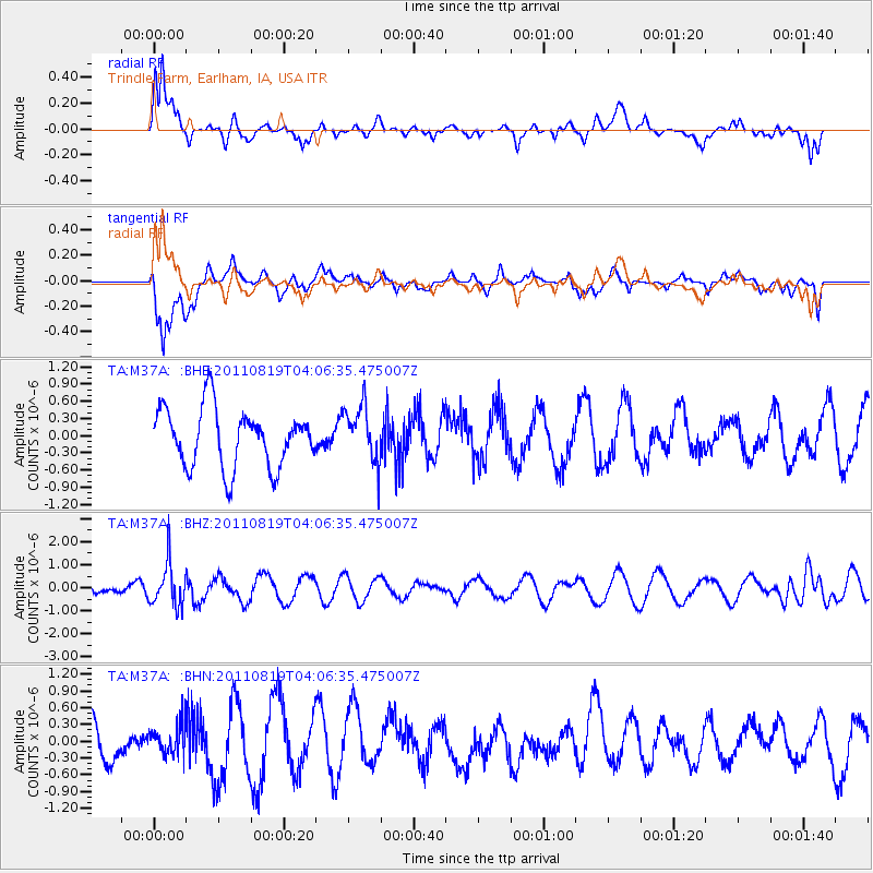
M37A Trindle Farm, Earlham, IA, USA - Earthquake Result Viewer
*The percent match for this event was below the threshold and hence no stack was calculated.
| Earthquake location: |
Fiji Islands Region |
| Earthquake latitude/longitude: |
-16.5/-177.0 |
| Earthquake time(UTC): |
2011/08/19 (231) 03:54:26 GMT |
| Earthquake Depth: |
408 km |
| Earthquake Magnitude: |
5.5 MB, 6.2 MW, 6.2 MW |
| Earthquake Catalog/Contributor: |
WHDF/NEIC |
|
| Network: |
TA USArray Transportable Network (new EarthScope stations) |
| Station: |
M37A Trindle Farm, Earlham, IA, USA |
| Lat/Lon: |
41.40 N/94.06 W |
| Elevation: |
325 m |
|
| Distance: |
95.6 deg |
| Az: |
48.605 deg |
| Baz: |
253.045 deg |
| Ray Param: |
$rayparam |
*The percent match for this event was below the threshold and hence was not used in the summary stack. |
|
| Radial Match: |
75.7237 % |
| Radial Bump: |
400 |
| Transverse Match: |
50.127697 % |
| Transverse Bump: |
400 |
| SOD ConfigId: |
410809 |
| Insert Time: |
2012-01-06 08:20:10.048 +0000 |
| GWidth: |
2.5 |
| Max Bumps: |
400 |
| Tol: |
0.001 |
|
Signal To Noise
| Channel | StoN | STA | LTA |
| TA:M37A: :BHZ:20110819T04:06:35.475007Z | 1.974637 | 9.3353964E-7 | 4.7276518E-7 |
| TA:M37A: :BHN:20110819T04:06:35.475007Z | 0.49705008 | 2.7846792E-7 | 5.602412E-7 |
| TA:M37A: :BHE:20110819T04:06:35.475007Z | 0.9691276 | 4.9085145E-7 | 5.0648794E-7 |
| Arrivals |
| Ps | |
| PpPs | |
| PsPs/PpSs | |


