You are here: Home > Network List > TA - USArray Transportable Network (new EarthScope stations) Stations List
> Station L37A Phoenix Point, Boone, IA, USA > Earthquake Result Viewer
L37A Phoenix Point, Boone, IA, USA - Earthquake Result Viewer
| Earthquake location: |
Fiji Islands Region |
| Earthquake latitude/longitude: |
-16.5/-177.0 |
| Earthquake time(UTC): |
2011/08/19 (231) 03:54:26 GMT |
| Earthquake Depth: |
408 km |
| Earthquake Magnitude: |
5.5 MB, 6.2 MW, 6.2 MW |
| Earthquake Catalog/Contributor: |
WHDF/NEIC |
|
| Network: |
TA USArray Transportable Network (new EarthScope stations) |
| Station: |
L37A Phoenix Point, Boone, IA, USA |
| Lat/Lon: |
42.12 N/93.75 W |
| Elevation: |
312 m |
|
| Distance: |
96.0 deg |
| Az: |
47.977 deg |
| Baz: |
253.31 deg |
| Ray Param: |
0.040229145 |
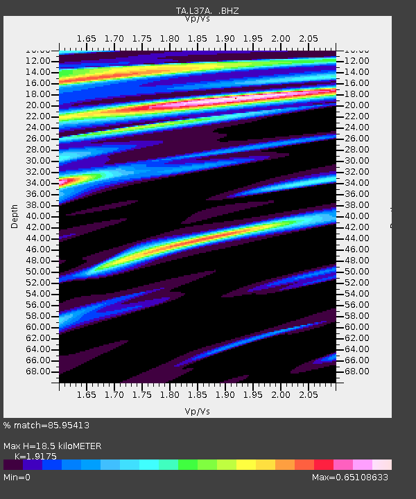
| Estimated Moho Depth: |
18.5 km |
| Estimated Crust Vp/Vs: |
1.92 |
| Assumed Crust Vp: |
6.53 km/s |
| Estimated Crust Vs: |
3.406 km/s |
| Estimated Crust Poisson's Ratio: |
0.31 |
|
| Radial Match: |
85.95413 % |
| Radial Bump: |
400 |
| Transverse Match: |
65.28356 % |
| Transverse Bump: |
400 |
| SOD ConfigId: |
410809 |
| Insert Time: |
2012-01-06 08:20:30.358 +0000 |
| GWidth: |
2.5 |
| Max Bumps: |
400 |
| Tol: |
0.001 |
|

Signal To Noise
| Channel | StoN | STA | LTA |
| TA:L37A: :BHZ:20110819T04:06:37.374971Z | 1.3744795 | 6.1039725E-7 | 4.4409336E-7 |
| TA:L37A: :BHN:20110819T04:06:37.374971Z | 0.76663196 | 3.2290882E-7 | 4.212045E-7 |
| TA:L37A: :BHE:20110819T04:06:37.374971Z | 1.5919427 | 4.1667062E-7 | 2.6173717E-7 |
| Arrivals |
| Ps | 2.6 SECOND |
| PpPs | 8.1 SECOND |
| PsPs/PpSs | 11 SECOND |


