You are here: Home > Network List > TA - USArray Transportable Network (new EarthScope stations) Stations List
> Station N36A Muff Farm, Clarinda, IA, USA > Earthquake Result Viewer
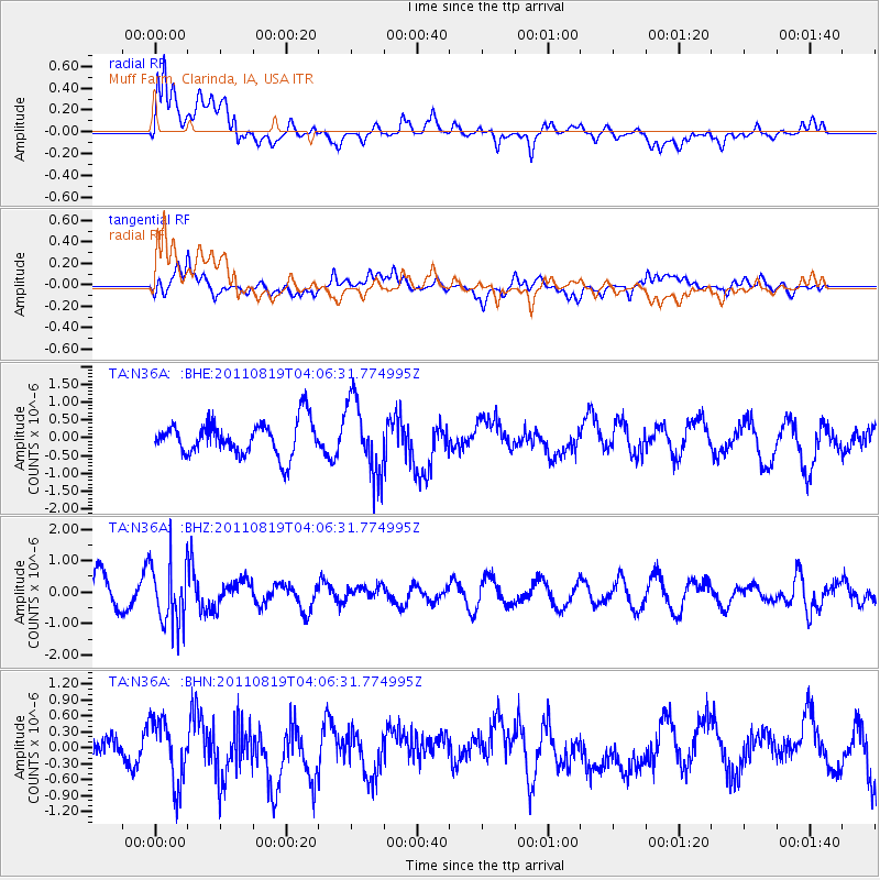
N36A Muff Farm, Clarinda, IA, USA - Earthquake Result Viewer
*The percent match for this event was below the threshold and hence no stack was calculated.
| Earthquake location: |
Fiji Islands Region |
| Earthquake latitude/longitude: |
-16.5/-177.0 |
| Earthquake time(UTC): |
2011/08/19 (231) 03:54:26 GMT |
| Earthquake Depth: |
408 km |
| Earthquake Magnitude: |
5.5 MB, 6.2 MW, 6.2 MW |
| Earthquake Catalog/Contributor: |
WHDF/NEIC |
|
| Network: |
TA USArray Transportable Network (new EarthScope stations) |
| Station: |
N36A Muff Farm, Clarinda, IA, USA |
| Lat/Lon: |
40.82 N/94.96 W |
| Elevation: |
349 m |
|
| Distance: |
94.8 deg |
| Az: |
48.964 deg |
| Baz: |
252.421 deg |
| Ray Param: |
$rayparam |
*The percent match for this event was below the threshold and hence was not used in the summary stack. |
|
| Radial Match: |
72.81782 % |
| Radial Bump: |
400 |
| Transverse Match: |
40.835236 % |
| Transverse Bump: |
400 |
| SOD ConfigId: |
410809 |
| Insert Time: |
2012-01-06 08:21:13.009 +0000 |
| GWidth: |
2.5 |
| Max Bumps: |
400 |
| Tol: |
0.001 |
|
Signal To Noise
| Channel | StoN | STA | LTA |
| TA:N36A: :BHZ:20110819T04:06:31.774995Z | 2.2356453 | 9.90554E-7 | 4.4307293E-7 |
| TA:N36A: :BHN:20110819T04:06:31.774995Z | 2.1474025 | 5.960633E-7 | 2.775741E-7 |
| TA:N36A: :BHE:20110819T04:06:31.774995Z | 2.1943395 | 1.0363826E-6 | 4.7229818E-7 |
| Arrivals |
| Ps | |
| PpPs | |
| PsPs/PpSs | |


