You are here: Home > Network List > UW - Pacific Northwest Regional Seismic Network Stations List
> Station FISH Seaside, OR, USA > Earthquake Result Viewer
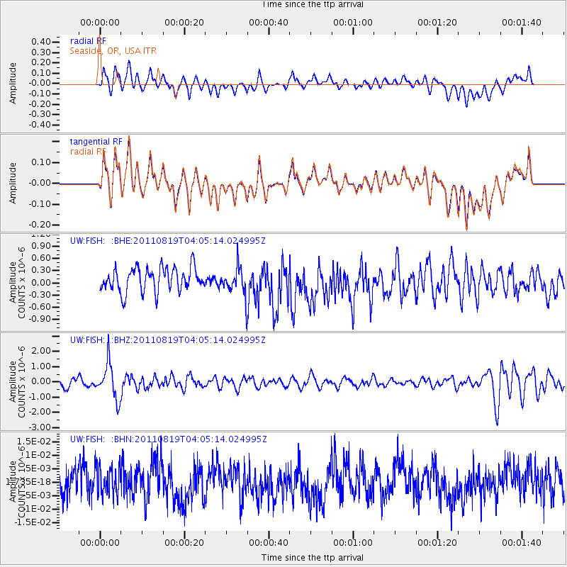
FISH Seaside, OR, USA - Earthquake Result Viewer
*The percent match for this event was below the threshold and hence no stack was calculated.
| Earthquake location: |
Fiji Islands Region |
| Earthquake latitude/longitude: |
-16.5/-177.0 |
| Earthquake time(UTC): |
2011/08/19 (231) 03:54:26 GMT |
| Earthquake Depth: |
408 km |
| Earthquake Magnitude: |
5.5 MB, 6.2 MW, 6.2 MW |
| Earthquake Catalog/Contributor: |
WHDF/NEIC |
|
| Network: |
UW Pacific Northwest Regional Seismic Network |
| Station: |
FISH Seaside, OR, USA |
| Lat/Lon: |
45.93 N/123.56 W |
| Elevation: |
325 m |
|
| Distance: |
78.7 deg |
| Az: |
34.874 deg |
| Baz: |
231.797 deg |
| Ray Param: |
$rayparam |
*The percent match for this event was below the threshold and hence was not used in the summary stack. |
|
| Radial Match: |
56.682976 % |
| Radial Bump: |
400 |
| Transverse Match: |
56.730057 % |
| Transverse Bump: |
400 |
| SOD ConfigId: |
410809 |
| Insert Time: |
2012-01-06 08:26:00.738 +0000 |
| GWidth: |
2.5 |
| Max Bumps: |
400 |
| Tol: |
0.001 |
|
Signal To Noise
| Channel | StoN | STA | LTA |
| UW:FISH: :BHZ:20110819T04:05:14.024995Z | 4.313097 | 1.1863069E-6 | 2.7504757E-7 |
| UW:FISH: :BHN:20110819T04:05:14.024995Z | 0.8503511 | 5.120913E-9 | 6.0221157E-9 |
| UW:FISH: :BHE:20110819T04:05:14.024995Z | 1.2567887 | 3.6367445E-7 | 2.8936802E-7 |
| Arrivals |
| Ps | |
| PpPs | |
| PsPs/PpSs | |


