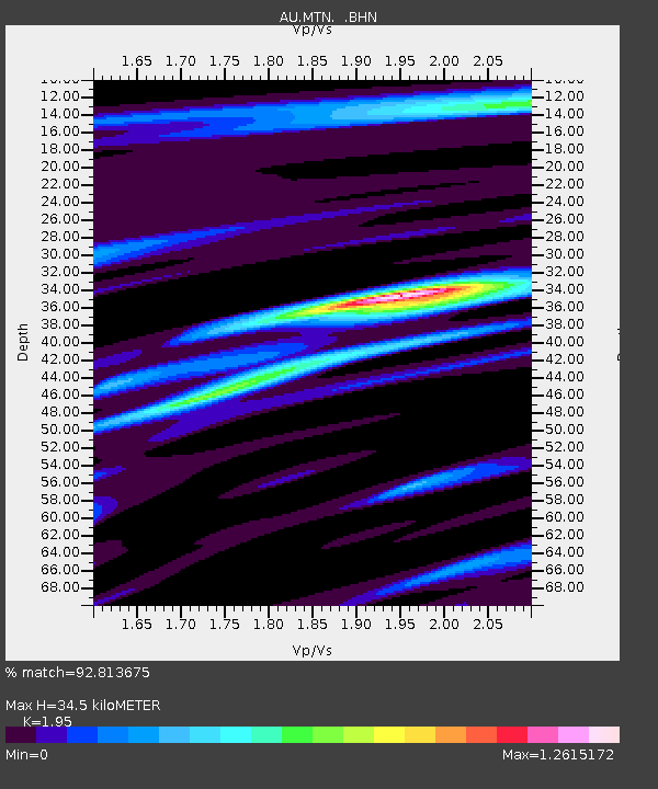
MTN Manton Dam, Northern Territory - Earthquake Result Viewer

Earthquake location: Near East Coast Of Honshu, Japan
Earthquake latitude/longitude: 37.7/141.7
Earthquake time(UTC): 2011/08/19 (231) 05:36:33 GMT
Earthquake Depth: 47 km
Earthquake Magnitude: 6.3 MB, 5.9 MS, 6.3 MW, 6.3 MW
Earthquake Catalog/Contributor: WHDF/NEIC
Network: AU Australian Seismological Centre
Station: MTN Manton Dam, Northern Territory
Lat/Lon: 12.84 S/131.13 E
Elevation: 137 m
Distance: 51.2 deg
Az: 193.206 deg
Baz: 10.712 deg
Ray Param: 0.0674485
Estimated Moho Depth: 34.5 km
Estimated Crust Vp/Vs: 1.95
Assumed Crust Vp: 6.61 km/s
Estimated Crust Vs: 3.39 km/s
Estimated Crust Poisson's Ratio: 0.32
Radial Match: 92.813675 %
Radial Bump: 329
Transverse Match: 74.797325 %
Transverse Bump: 400
SOD ConfigId: 410809
Insert Time: 2012-01-06 08:37:46.898 +0000
GWidth: 2.5
Max Bumps: 400
Tol: 0.001

Signal To Noise

ChannelStoNSTALTA
AU:MTN: :BHZ:20110819T05:45:01.170005Z9.3236393.1512018E-63.3797983E-7
AU:MTN: :BHN:20110819T05:45:01.170005Z9.8789842.0936768E-62.119324E-7
AU:MTN: :BHE:20110819T05:45:01.170005Z1.62892654.4337105E-72.7218604E-7
Arrivals
Ps5.2 SECOND
PpPs15 SECOND
PsPs/PpSs20 SECOND