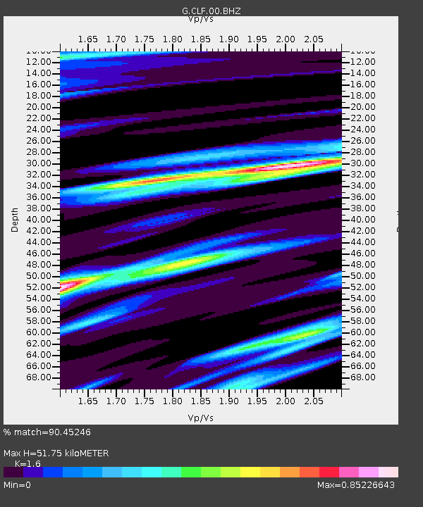
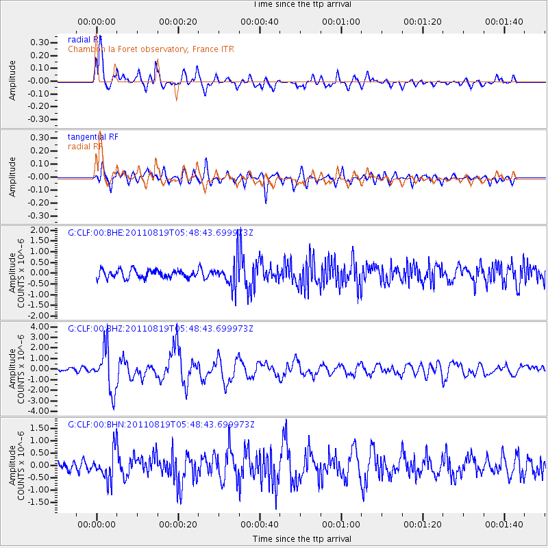
CLF Chambon la Foret observatory, France - Earthquake Result Viewer

Earthquake location: Near East Coast Of Honshu, Japan
Earthquake latitude/longitude: 37.7/141.7
Earthquake time(UTC): 2011/08/19 (231) 05:36:33 GMT
Earthquake Depth: 47 km
Earthquake Magnitude: 6.3 MB, 5.9 MS, 6.3 MW, 6.3 MW
Earthquake Catalog/Contributor: WHDF/NEIC
Network: G GEOSCOPE
Station: CLF Chambon la Foret observatory, France
Lat/Lon: 48.03 N/2.26 E
Elevation: 145 m
Distance: 87.3 deg
Az: 334.062 deg
Baz: 31.134 deg
Ray Param: 0.043331884
Estimated Moho Depth: 51.75 km
Estimated Crust Vp/Vs: 1.60
Assumed Crust Vp: 6.12 km/s
Estimated Crust Vs: 3.825 km/s
Estimated Crust Poisson's Ratio: 0.18
Radial Match: 90.45246 %
Radial Bump: 400
Transverse Match: 80.37915 %
Transverse Bump: 400
SOD ConfigId: 410809
Insert Time: 2012-01-06 08:48:43.952 +0000
GWidth: 2.5
Max Bumps: 400
Tol: 0.001

Signal To Noise

ChannelStoNSTALTA
G:CLF:00:BHZ:20110819T05:48:43.699973Z14.871672.0690884E-61.3912953E-7
G:CLF:00:BHN:20110819T05:48:43.699973Z3.55648185.8215886E-71.6368953E-7
G:CLF:00:BHE:20110819T05:48:43.699973Z3.4734456.350498E-71.8282995E-7
Arrivals
Ps5.2 SECOND
PpPs21 SECOND
PsPs/PpSs27 SECOND