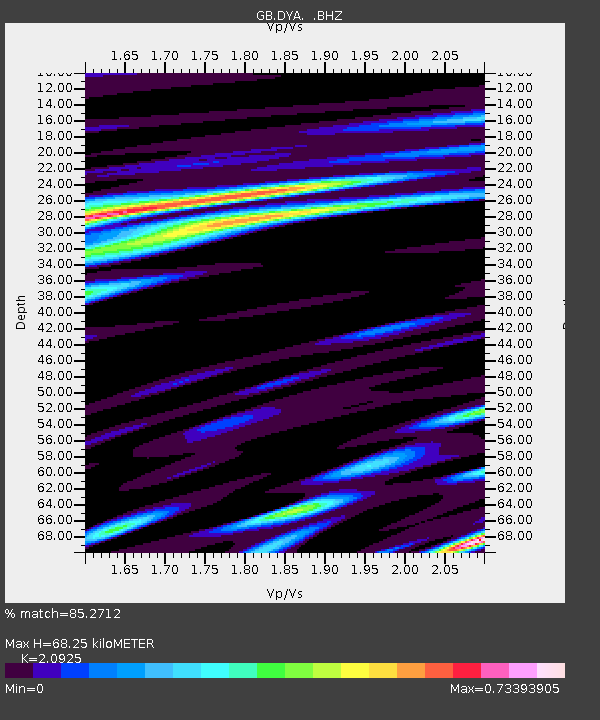
DYA YADSWORTHY, ENGLAND - Earthquake Result Viewer

Earthquake location: Near East Coast Of Honshu, Japan
Earthquake latitude/longitude: 37.7/141.7
Earthquake time(UTC): 2011/08/19 (231) 05:36:33 GMT
Earthquake Depth: 47 km
Earthquake Magnitude: 6.3 MB, 5.9 MS, 6.3 MW, 6.3 MW
Earthquake Catalog/Contributor: WHDF/NEIC
Network: GB Great Britain Seismograph Network
Station: DYA YADSWORTHY, ENGLAND
Lat/Lon: 50.44 N/3.93 W
Elevation: 292 m
Distance: 87.2 deg
Az: 338.784 deg
Baz: 26.683 deg
Ray Param: 0.04343475
Estimated Moho Depth: 68.25 km
Estimated Crust Vp/Vs: 2.09
Assumed Crust Vp: 6.182 km/s
Estimated Crust Vs: 2.954 km/s
Estimated Crust Poisson's Ratio: 0.35
Radial Match: 85.2712 %
Radial Bump: 400
Transverse Match: 67.396416 %
Transverse Bump: 400
SOD ConfigId: 410809
Insert Time: 2012-01-06 08:48:59.681 +0000
GWidth: 2.5
Max Bumps: 400
Tol: 0.001

Signal To Noise

ChannelStoNSTALTA
GB:DYA: :BHZ:20110819T05:48:42.985007Z11.697761.8135395E-61.5503306E-7
GB:DYA: :BHN:20110819T05:48:42.985007Z2.87461474.107948E-71.429043E-7
GB:DYA: :BHE:20110819T05:48:42.985007Z2.52216393.421221E-71.3564626E-7
Arrivals
Ps12 SECOND
PpPs34 SECOND
PsPs/PpSs46 SECOND