You are here: Home > Network List > IW - Intermountain West Stations List
> Station PHWY Pilot Hill, Wyoming, USA > Earthquake Result Viewer
PHWY Pilot Hill, Wyoming, USA - Earthquake Result Viewer
| Earthquake location: |
Near East Coast Of Honshu, Japan |
| Earthquake latitude/longitude: |
37.7/141.7 |
| Earthquake time(UTC): |
2011/08/19 (231) 05:36:33 GMT |
| Earthquake Depth: |
47 km |
| Earthquake Magnitude: |
6.3 MB, 5.9 MS, 6.3 MW, 6.3 MW |
| Earthquake Catalog/Contributor: |
WHDF/NEIC |
|
| Network: |
IW Intermountain West |
| Station: |
PHWY Pilot Hill, Wyoming, USA |
| Lat/Lon: |
41.30 N/105.46 W |
| Elevation: |
2645 m |
|
| Distance: |
80.4 deg |
| Az: |
44.754 deg |
| Baz: |
312.14 deg |
| Ray Param: |
0.04825454 |
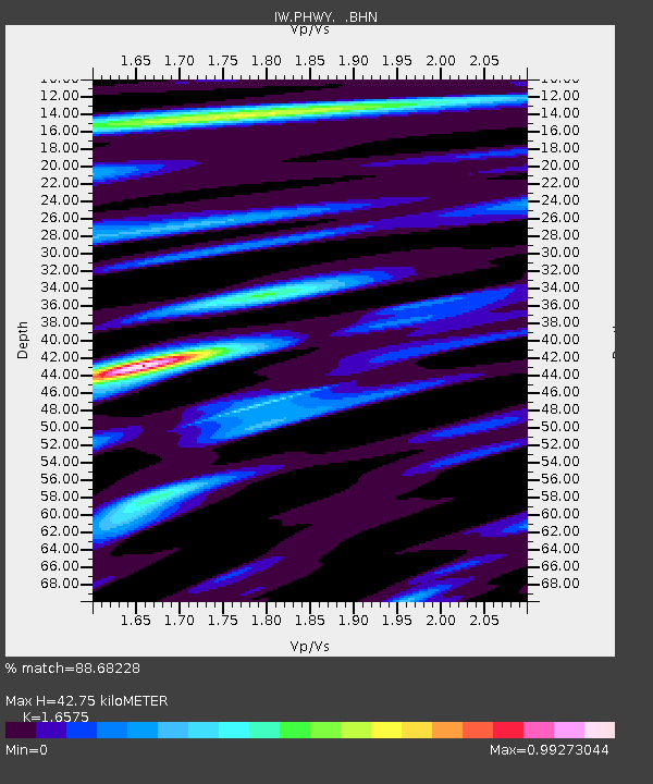
| Estimated Moho Depth: |
42.75 km |
| Estimated Crust Vp/Vs: |
1.66 |
| Assumed Crust Vp: |
6.306 km/s |
| Estimated Crust Vs: |
3.805 km/s |
| Estimated Crust Poisson's Ratio: |
0.21 |
|
| Radial Match: |
88.68228 % |
| Radial Bump: |
400 |
| Transverse Match: |
74.31755 % |
| Transverse Bump: |
367 |
| SOD ConfigId: |
410809 |
| Insert Time: |
2012-01-06 08:51:50.413 +0000 |
| GWidth: |
2.5 |
| Max Bumps: |
400 |
| Tol: |
0.001 |
|

Signal To Noise
| Channel | StoN | STA | LTA |
| IW:PHWY: :BHZ:20110819T05:48:08.264976Z | 19.682827 | 2.3237362E-6 | 1.1805906E-7 |
| IW:PHWY: :BHN:20110819T05:48:08.264976Z | 4.6022935 | 7.4416084E-7 | 1.6169349E-7 |
| IW:PHWY: :BHE:20110819T05:48:08.264976Z | 4.089924 | 5.5289684E-7 | 1.3518512E-7 |
| Arrivals |
| Ps | 4.6 SECOND |
| PpPs | 18 SECOND |
| PsPs/PpSs | 22 SECOND |


