You are here: Home > Network List > IW - Intermountain West Stations List
> Station DLMT Dillon, Montana, USA > Earthquake Result Viewer
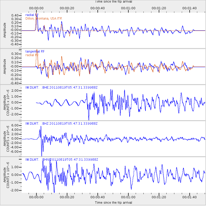
DLMT Dillon, Montana, USA - Earthquake Result Viewer
*The percent match for this event was below the threshold and hence no stack was calculated.
| Earthquake location: |
Near East Coast Of Honshu, Japan |
| Earthquake latitude/longitude: |
37.7/141.7 |
| Earthquake time(UTC): |
2011/08/19 (231) 05:36:33 GMT |
| Earthquake Depth: |
47 km |
| Earthquake Magnitude: |
6.3 MB, 5.9 MS, 6.3 MW, 6.3 MW |
| Earthquake Catalog/Contributor: |
WHDF/NEIC |
|
| Network: |
IW Intermountain West |
| Station: |
DLMT Dillon, Montana, USA |
| Lat/Lon: |
45.36 N/112.60 W |
| Elevation: |
1569 m |
|
| Distance: |
73.8 deg |
| Az: |
44.97 deg |
| Baz: |
307.3 deg |
| Ray Param: |
$rayparam |
*The percent match for this event was below the threshold and hence was not used in the summary stack. |
|
| Radial Match: |
77.08709 % |
| Radial Bump: |
400 |
| Transverse Match: |
80.09585 % |
| Transverse Bump: |
400 |
| SOD ConfigId: |
410809 |
| Insert Time: |
2012-01-06 08:52:05.686 +0000 |
| GWidth: |
2.5 |
| Max Bumps: |
400 |
| Tol: |
0.001 |
|
Signal To Noise
| Channel | StoN | STA | LTA |
| IW:DLMT: :BHZ:20110819T05:47:31.339988Z | 13.23914 | 2.886913E-6 | 2.1805897E-7 |
| IW:DLMT: :BHN:20110819T05:47:31.339988Z | 2.6092575 | 6.679501E-7 | 2.559924E-7 |
| IW:DLMT: :BHE:20110819T05:47:31.339988Z | 3.1614416 | 9.2257693E-7 | 2.918216E-7 |
| Arrivals |
| Ps | |
| PpPs | |
| PsPs/PpSs | |


