You are here: Home > Network List > G - GEOSCOPE Stations List
> Station DRV Dumont d'Urville, Terre Adelie (Antartica) > Earthquake Result Viewer
DRV Dumont d'Urville, Terre Adelie (Antartica) - Earthquake Result Viewer
| Earthquake location: |
Vanuatu Islands |
| Earthquake latitude/longitude: |
-15.1/167.4 |
| Earthquake time(UTC): |
1997/11/15 (319) 18:59:24 GMT |
| Earthquake Depth: |
123 km |
| Earthquake Magnitude: |
6.4 MB, 7.0 UNKNOWN, 6.8 ME |
| Earthquake Catalog/Contributor: |
WHDF/NEIC |
|
| Network: |
G GEOSCOPE |
| Station: |
DRV Dumont d'Urville, Terre Adelie (Antartica) |
| Lat/Lon: |
66.67 S/140.01 E |
| Elevation: |
40 m |
|
| Distance: |
54.6 deg |
| Az: |
192.987 deg |
| Baz: |
33.012 deg |
| Ray Param: |
0.064974025 |
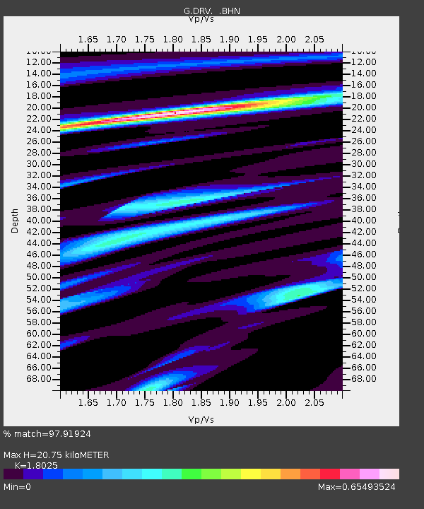
| Estimated Moho Depth: |
20.75 km |
| Estimated Crust Vp/Vs: |
1.80 |
| Assumed Crust Vp: |
6.39 km/s |
| Estimated Crust Vs: |
3.545 km/s |
| Estimated Crust Poisson's Ratio: |
0.28 |
|
| Radial Match: |
97.91924 % |
| Radial Bump: |
272 |
| Transverse Match: |
91.5372 % |
| Transverse Bump: |
400 |
| SOD ConfigId: |
4480 |
| Insert Time: |
2010-02-26 22:07:59.125 +0000 |
| GWidth: |
2.5 |
| Max Bumps: |
400 |
| Tol: |
0.001 |
|

Signal To Noise
| Channel | StoN | STA | LTA |
| G:DRV: :BHN:19971115T19:08:09.182019Z | 18.137321 | 2.9868982E-6 | 1.6468242E-7 |
| G:DRV: :BHE:19971115T19:08:09.182019Z | 20.388784 | 1.47647E-6 | 7.2415794E-8 |
| G:DRV: :BHZ:19971115T19:08:09.182019Z | 14.250264 | 1.081933E-6 | 7.5923715E-8 |
| Arrivals |
| Ps | 2.7 SECOND |
| PpPs | 8.7 SECOND |
| PsPs/PpSs | 11 SECOND |


