You are here: Home > Network List > TA - USArray Transportable Network (new EarthScope stations) Stations List
> Station R11A Troy Canyon, Currant, NV, USA > Earthquake Result Viewer
R11A Troy Canyon, Currant, NV, USA - Earthquake Result Viewer
| Earthquake location: |
Near East Coast Of Honshu, Japan |
| Earthquake latitude/longitude: |
37.7/141.7 |
| Earthquake time(UTC): |
2011/08/19 (231) 05:36:33 GMT |
| Earthquake Depth: |
47 km |
| Earthquake Magnitude: |
6.3 MB, 5.9 MS, 6.3 MW, 6.3 MW |
| Earthquake Catalog/Contributor: |
WHDF/NEIC |
|
| Network: |
TA USArray Transportable Network (new EarthScope stations) |
| Station: |
R11A Troy Canyon, Currant, NV, USA |
| Lat/Lon: |
38.35 N/115.59 W |
| Elevation: |
1756 m |
|
| Distance: |
76.2 deg |
| Az: |
52.145 deg |
| Baz: |
307.17 deg |
| Ray Param: |
0.051056236 |
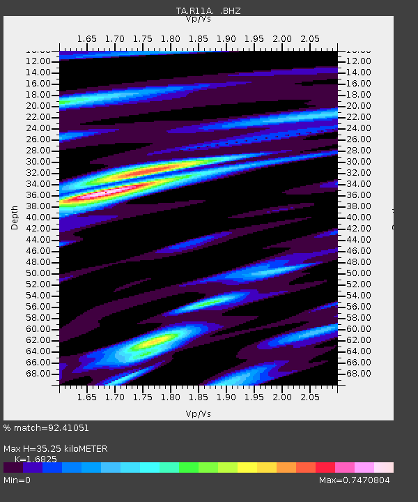
| Estimated Moho Depth: |
35.25 km |
| Estimated Crust Vp/Vs: |
1.68 |
| Assumed Crust Vp: |
6.276 km/s |
| Estimated Crust Vs: |
3.73 km/s |
| Estimated Crust Poisson's Ratio: |
0.23 |
|
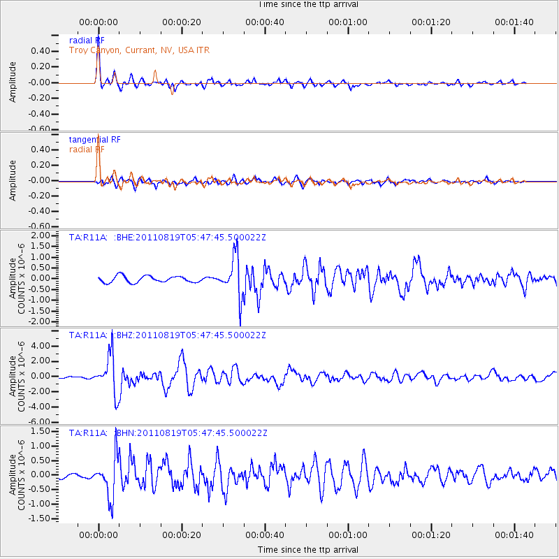
| Radial Match: |
92.41051 % |
| Radial Bump: |
400 |
| Transverse Match: |
88.203255 % |
| Transverse Bump: |
400 |
| SOD ConfigId: |
410809 |
| Insert Time: |
2012-01-06 09:00:37.175 +0000 |
| GWidth: |
2.5 |
| Max Bumps: |
400 |
| Tol: |
0.001 |
|
Signal To Noise
| Channel | StoN | STA | LTA |
| TA:R11A: :BHZ:20110819T05:47:45.500022Z | 15.930474 | 2.6161956E-6 | 1.6422584E-7 |
| TA:R11A: :BHN:20110819T05:47:45.500022Z | 13.5762205 | 7.1545537E-7 | 5.2699153E-8 |
| TA:R11A: :BHE:20110819T05:47:45.500022Z | 6.4428563 | 9.552825E-7 | 1.4827002E-7 |
| Arrivals |
| Ps | 4.0 SECOND |
| PpPs | 15 SECOND |
| PsPs/PpSs | 19 SECOND |


