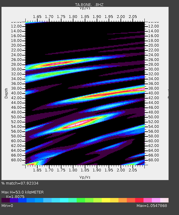
BGNE Belgrade, NE, USA - Earthquake Result Viewer

Earthquake location: Near East Coast Of Honshu, Japan
Earthquake latitude/longitude: 37.7/141.7
Earthquake time(UTC): 2011/08/19 (231) 05:36:33 GMT
Earthquake Depth: 47 km
Earthquake Magnitude: 6.3 MB, 5.9 MS, 6.3 MW, 6.3 MW
Earthquake Catalog/Contributor: WHDF/NEIC
Network: TA USArray Transportable Network (new EarthScope stations)
Station: BGNE Belgrade, NE, USA
Lat/Lon: 41.41 N/98.15 W
Elevation: 573 m
Distance: 84.2 deg
Az: 40.803 deg
Baz: 316.422 deg
Ray Param: 0.045562852
Estimated Moho Depth: 53.0 km
Estimated Crust Vp/Vs: 1.81
Assumed Crust Vp: 6.53 km/s
Estimated Crust Vs: 3.613 km/s
Estimated Crust Poisson's Ratio: 0.28
Radial Match: 87.92334 %
Radial Bump: 400
Transverse Match: 83.03293 %
Transverse Bump: 400
SOD ConfigId: 410809
Insert Time: 2012-01-06 09:02:48.787 +0000
GWidth: 2.5
Max Bumps: 400
Tol: 0.001

Signal To Noise

ChannelStoNSTALTA
TA:BGNE: :BHZ:20110819T05:48:28.349998Z18.6912633.781637E-62.0232109E-7
TA:BGNE: :BHN:20110819T05:48:28.349998Z4.26449061.294922E-63.036522E-7
TA:BGNE: :BHE:20110819T05:48:28.349998Z3.56819631.2182493E-63.414188E-7
Arrivals
Ps6.7 SECOND
PpPs22 SECOND
PsPs/PpSs29 SECOND