G03D McMinnville, OR, USA - Earthquake Result Viewer
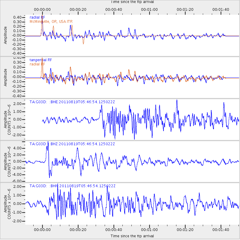
Earthquake location: Near East Coast Of Honshu, Japan
Earthquake latitude/longitude: 37.7/141.7
Earthquake time(UTC): 2011/08/19 (231) 05:36:33 GMT
Earthquake Depth: 47 km
Earthquake Magnitude: 6.3 MB, 5.9 MS, 6.3 MW, 6.3 MW
Earthquake Catalog/Contributor: WHDF/NEIC
Network: TA USArray Transportable Network (new EarthScope stations)
Station: G03D McMinnville, OR, USA
Lat/Lon: 45.21 N/123.26 W
Elevation: 222 m
Distance: 67.6 deg
Az: 49.592 deg
Baz: 301.265 deg
Ray Param: 0.056745566
Estimated Moho Depth: 35.25 km
Estimated Crust Vp/Vs: 2.03
Assumed Crust Vp: 6.566 km/s
Estimated Crust Vs: 3.231 km/s
Estimated Crust Poisson's Ratio: 0.34
Radial Match: 83.99701 %
Radial Bump: 400
Transverse Match: 82.5614 %
Transverse Bump: 400
SOD ConfigId: 410809
Insert Time: 2012-01-06 09:05:21.105 +0000
GWidth: 2.5
Max Bumps: 400
Tol: 0.001

Signal To Noise

ChannelStoNSTALTA
TA:G03D: :BHZ:20110819T05:46:54.125022Z14.7906652.714358E-61.8351834E-7
TA:G03D: :BHN:20110819T05:46:54.125022Z2.98720625.045792E-71.689134E-7
TA:G03D: :BHE:20110819T05:46:54.125022Z3.5915527.559978E-72.1049334E-7
Arrivals
Ps5.7 SECOND
PpPs16 SECOND
PsPs/PpSs21 SECOND