You are here: Home > Network List > TA - USArray Transportable Network (new EarthScope stations) Stations List
> Station Z35A Perchaven, Sanger, TX, USA > Earthquake Result Viewer
Z35A Perchaven, Sanger, TX, USA - Earthquake Result Viewer
| Earthquake location: |
Near East Coast Of Honshu, Japan |
| Earthquake latitude/longitude: |
37.7/141.7 |
| Earthquake time(UTC): |
2011/08/19 (231) 05:36:33 GMT |
| Earthquake Depth: |
47 km |
| Earthquake Magnitude: |
6.3 MB, 5.9 MS, 6.3 MW, 6.3 MW |
| Earthquake Catalog/Contributor: |
WHDF/NEIC |
|
| Network: |
TA USArray Transportable Network (new EarthScope stations) |
| Station: |
Z35A Perchaven, Sanger, TX, USA |
| Lat/Lon: |
33.33 N/97.25 W |
| Elevation: |
235 m |
|
| Distance: |
90.6 deg |
| Az: |
45.803 deg |
| Baz: |
317.193 deg |
| Ray Param: |
0.04165548 |
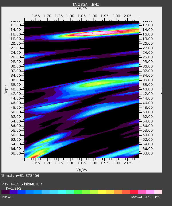
| Estimated Moho Depth: |
15.5 km |
| Estimated Crust Vp/Vs: |
1.89 |
| Assumed Crust Vp: |
6.38 km/s |
| Estimated Crust Vs: |
3.367 km/s |
| Estimated Crust Poisson's Ratio: |
0.31 |
|
| Radial Match: |
81.378456 % |
| Radial Bump: |
400 |
| Transverse Match: |
73.36783 % |
| Transverse Bump: |
400 |
| SOD ConfigId: |
410809 |
| Insert Time: |
2012-01-06 09:07:59.089 +0000 |
| GWidth: |
2.5 |
| Max Bumps: |
400 |
| Tol: |
0.001 |
|
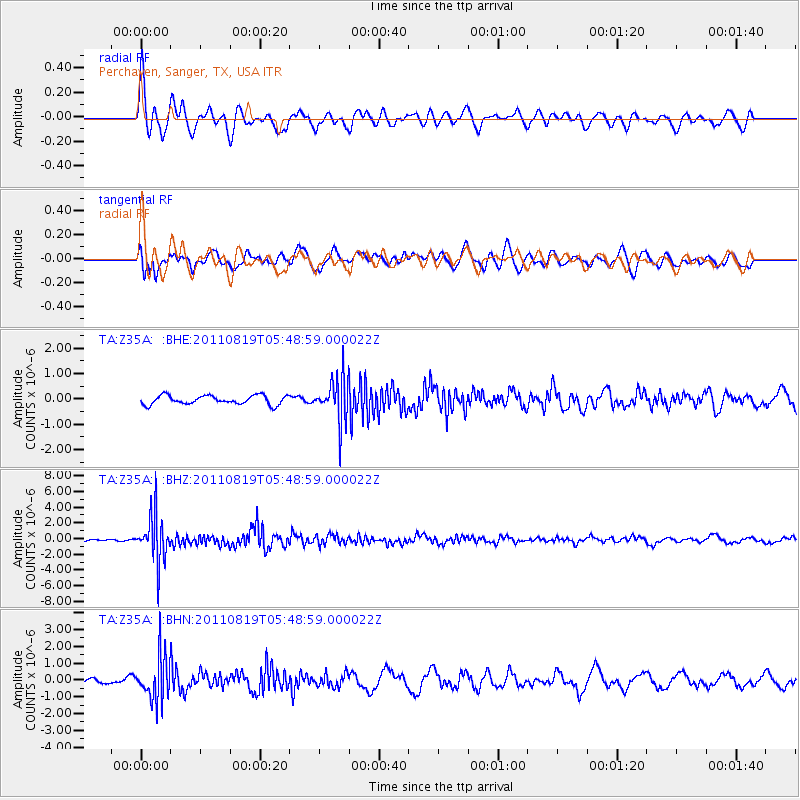
Signal To Noise
| Channel | StoN | STA | LTA |
| TA:Z35A: :BHZ:20110819T05:48:59.000022Z | 49.15874 | 2.9652965E-6 | 6.032084E-8 |
| TA:Z35A: :BHN:20110819T05:48:59.000022Z | 11.461904 | 1.3028703E-6 | 1.1366962E-7 |
| TA:Z35A: :BHE:20110819T05:48:59.000022Z | 4.84423 | 8.5606183E-7 | 1.7671782E-7 |
| Arrivals |
| Ps | 2.2 SECOND |
| PpPs | 6.9 SECOND |
| PsPs/PpSs | 9.1 SECOND |


