You are here: Home > Network List > TA - USArray Transportable Network (new EarthScope stations) Stations List
> Station 536A Bastrop, TX, USA > Earthquake Result Viewer
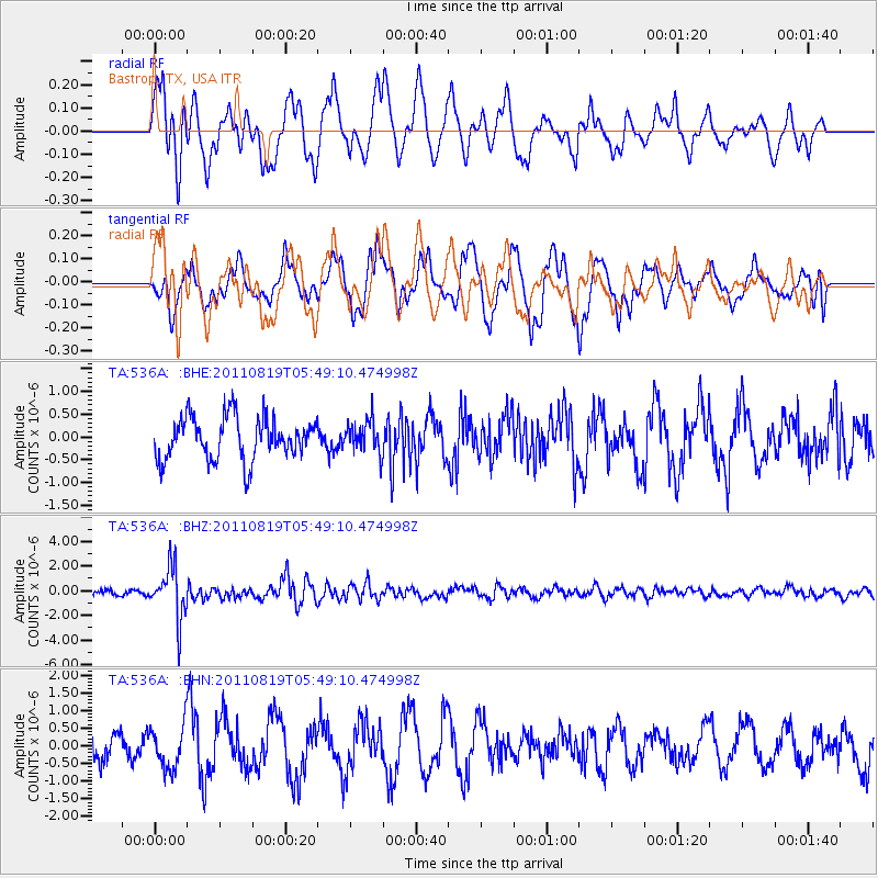
536A Bastrop, TX, USA - Earthquake Result Viewer
*The percent match for this event was below the threshold and hence no stack was calculated.
| Earthquake location: |
Near East Coast Of Honshu, Japan |
| Earthquake latitude/longitude: |
37.7/141.7 |
| Earthquake time(UTC): |
2011/08/19 (231) 05:36:33 GMT |
| Earthquake Depth: |
47 km |
| Earthquake Magnitude: |
6.3 MB, 5.9 MS, 6.3 MW, 6.3 MW |
| Earthquake Catalog/Contributor: |
WHDF/NEIC |
|
| Network: |
TA USArray Transportable Network (new EarthScope stations) |
| Station: |
536A Bastrop, TX, USA |
| Lat/Lon: |
30.08 N/97.07 W |
| Elevation: |
115 m |
|
| Distance: |
93.1 deg |
| Az: |
47.891 deg |
| Baz: |
317.224 deg |
| Ray Param: |
$rayparam |
*The percent match for this event was below the threshold and hence was not used in the summary stack. |
|
| Radial Match: |
80.87826 % |
| Radial Bump: |
400 |
| Transverse Match: |
60.17971 % |
| Transverse Bump: |
400 |
| SOD ConfigId: |
410809 |
| Insert Time: |
2012-01-06 09:10:56.344 +0000 |
| GWidth: |
2.5 |
| Max Bumps: |
400 |
| Tol: |
0.001 |
|
Signal To Noise
| Channel | StoN | STA | LTA |
| TA:536A: :BHZ:20110819T05:49:10.474998Z | 8.718401 | 2.1056592E-6 | 2.4151896E-7 |
| TA:536A: :BHN:20110819T05:49:10.474998Z | 1.0208981 | 5.987581E-7 | 5.8650136E-7 |
| TA:536A: :BHE:20110819T05:49:10.474998Z | 0.7439571 | 3.4562274E-7 | 4.6457347E-7 |
| Arrivals |
| Ps | |
| PpPs | |
| PsPs/PpSs | |


