You are here: Home > Network List > TA - USArray Transportable Network (new EarthScope stations) Stations List
> Station M34A Aspy Farms, Fremont, NE, USA > Earthquake Result Viewer
M34A Aspy Farms, Fremont, NE, USA - Earthquake Result Viewer

| Earthquake location: |
Near East Coast Of Honshu, Japan |
| Earthquake latitude/longitude: |
37.7/141.7 |
| Earthquake time(UTC): |
2011/08/19 (231) 05:36:33 GMT |
| Earthquake Depth: |
47 km |
| Earthquake Magnitude: |
6.3 MB, 5.9 MS, 6.3 MW, 6.3 MW |
| Earthquake Catalog/Contributor: |
WHDF/NEIC |
|
| Network: |
TA USArray Transportable Network (new EarthScope stations) |
| Station: |
M34A Aspy Farms, Fremont, NE, USA |
| Lat/Lon: |
41.50 N/96.58 W |
| Elevation: |
415 m |
|
| Distance: |
85.0 deg |
| Az: |
39.874 deg |
| Baz: |
317.368 deg |
| Ray Param: |
0.045034517 |
| Estimated Moho Depth: |
28.75 km |
| Estimated Crust Vp/Vs: |
1.65 |
| Assumed Crust Vp: |
6.498 km/s |
| Estimated Crust Vs: |
3.926 km/s |
| Estimated Crust Poisson's Ratio: |
0.21 |
|
| Radial Match: |
86.48489 % |
| Radial Bump: |
400 |
| Transverse Match: |
68.97589 % |
| Transverse Bump: |
400 |
| SOD ConfigId: |
410809 |
| Insert Time: |
2012-01-06 09:18:04.599 +0000 |
| GWidth: |
2.5 |
| Max Bumps: |
400 |
| Tol: |
0.001 |
|
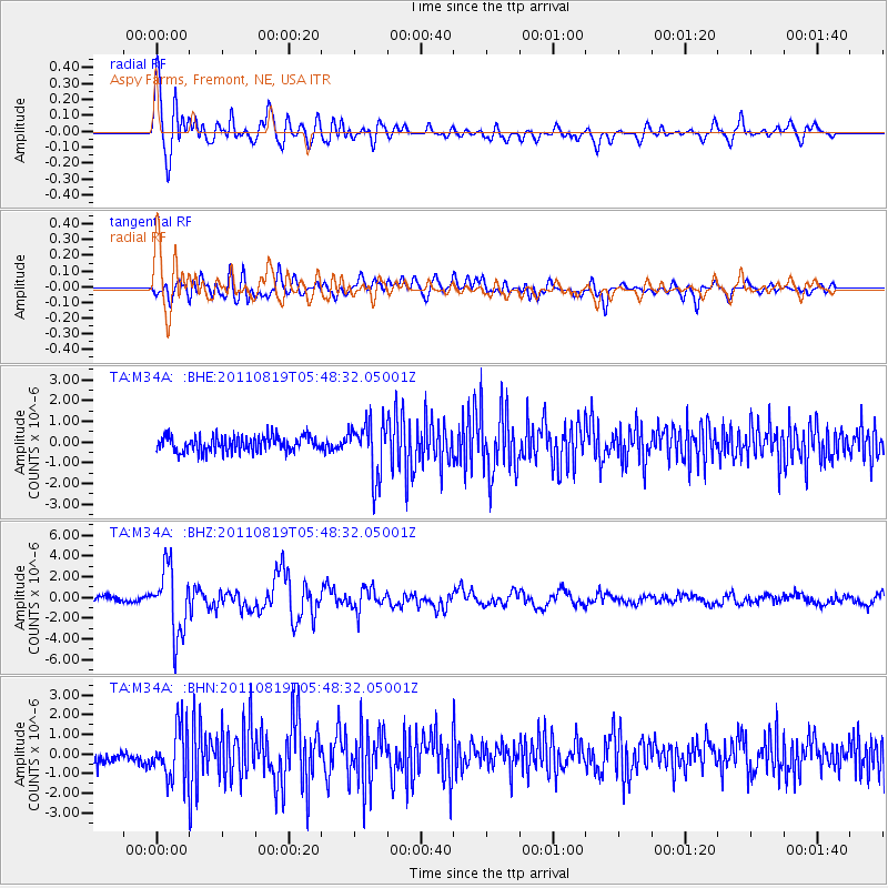
Signal To Noise
| Channel | StoN | STA | LTA |
| TA:M34A: :BHZ:20110819T05:48:32.05001Z | 11.608006 | 3.18738E-6 | 2.7458464E-7 |
| TA:M34A: :BHN:20110819T05:48:32.05001Z | 2.974562 | 1.2935035E-6 | 4.3485514E-7 |
| TA:M34A: :BHE:20110819T05:48:32.05001Z | 3.438144 | 1.2999594E-6 | 3.7809917E-7 |
| Arrivals |
| Ps | 3.0 SECOND |
| PpPs | 11 SECOND |
| PsPs/PpSs | 14 SECOND |


