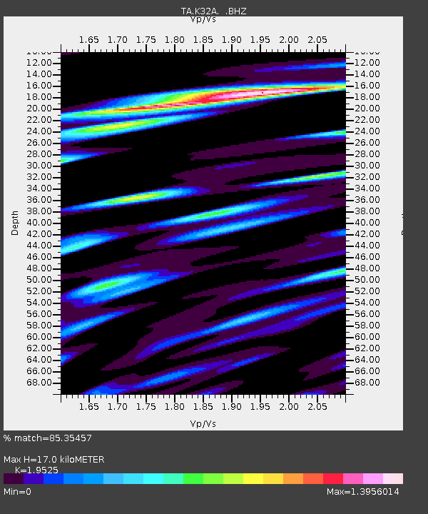
K32A Verdigre, NE, USA - Earthquake Result Viewer
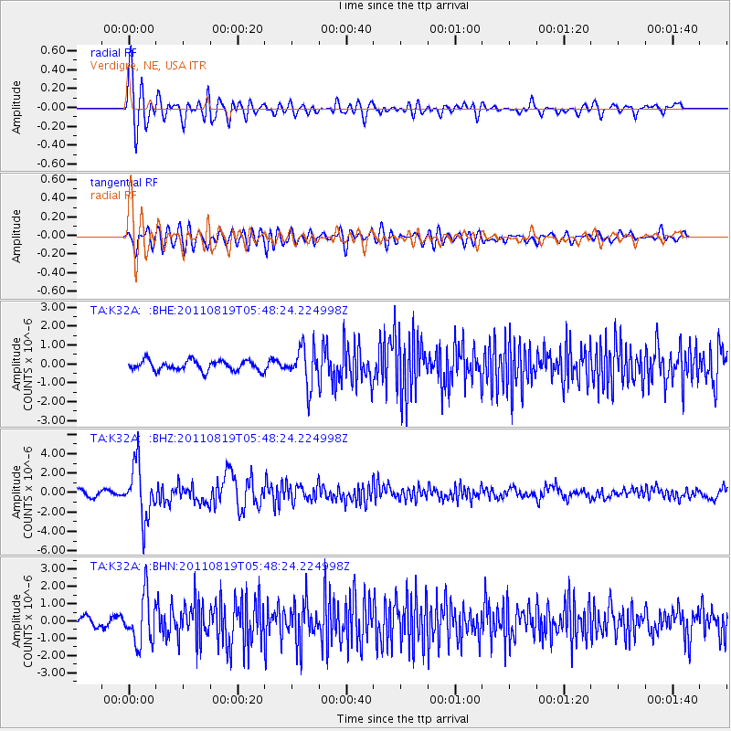
Earthquake location: Near East Coast Of Honshu, Japan
Earthquake latitude/longitude: 37.7/141.7
Earthquake time(UTC): 2011/08/19 (231) 05:36:33 GMT
Earthquake Depth: 47 km
Earthquake Magnitude: 6.3 MB, 5.9 MS, 6.3 MW, 6.3 MW
Earthquake Catalog/Contributor: WHDF/NEIC
Network: TA USArray Transportable Network (new EarthScope stations)
Station: K32A Verdigre, NE, USA
Lat/Lon: 42.66 N/97.97 W
Elevation: 512 m
Distance: 83.4 deg
Az: 39.839 deg
Baz: 316.437 deg
Ray Param: 0.046134192
Estimated Moho Depth: 17.0 km
Estimated Crust Vp/Vs: 1.95
Assumed Crust Vp: 6.498 km/s
Estimated Crust Vs: 3.328 km/s
Estimated Crust Poisson's Ratio: 0.32
Radial Match: 85.35457 %
Radial Bump: 400
Transverse Match: 66.25712 %
Transverse Bump: 400
SOD ConfigId: 410809
Insert Time: 2012-01-06 09:20:24.295 +0000
GWidth: 2.5
Max Bumps: 400
Tol: 0.001

Signal To Noise

ChannelStoNSTALTA
TA:K32A: :BHZ:20110819T05:48:24.224998Z9.0044642.8006702E-63.110313E-7
TA:K32A: :BHN:20110819T05:48:24.224998Z5.09712121.4020894E-62.7507477E-7
TA:K32A: :BHE:20110819T05:48:24.224998Z3.76127651.002136E-62.6643505E-7
Arrivals
Ps2.6 SECOND
PpPs7.5 SECOND
PsPs/PpSs10 SECOND