K31A O'Neill, NE, USA - Earthquake Result Viewer
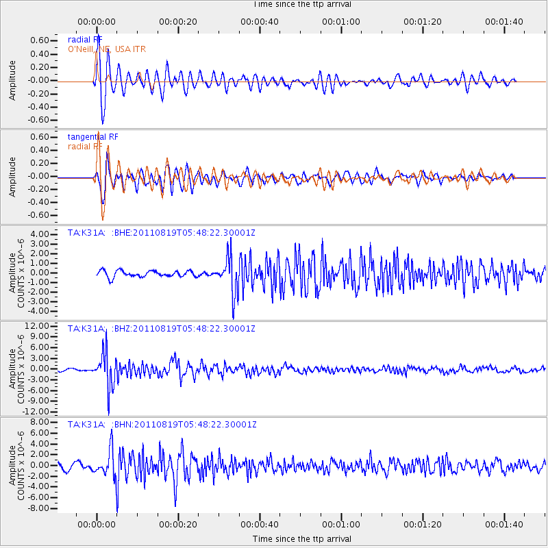
Earthquake location: Near East Coast Of Honshu, Japan
Earthquake latitude/longitude: 37.7/141.7
Earthquake time(UTC): 2011/08/19 (231) 05:36:33 GMT
Earthquake Depth: 47 km
Earthquake Magnitude: 6.3 MB, 5.9 MS, 6.3 MW, 6.3 MW
Earthquake Catalog/Contributor: WHDF/NEIC
Network: TA USArray Transportable Network (new EarthScope stations)
Station: K31A O'Neill, NE, USA
Lat/Lon: 42.62 N/98.75 W
Elevation: 580 m
Distance: 83.0 deg
Az: 40.285 deg
Baz: 315.962 deg
Ray Param: 0.046398226
Estimated Moho Depth: 25.75 km
Estimated Crust Vp/Vs: 1.76
Assumed Crust Vp: 6.53 km/s
Estimated Crust Vs: 3.716 km/s
Estimated Crust Poisson's Ratio: 0.26
Radial Match: 90.04145 %
Radial Bump: 400
Transverse Match: 85.555145 %
Transverse Bump: 400
SOD ConfigId: 410809
Insert Time: 2012-01-06 09:24:42.633 +0000
GWidth: 2.5
Max Bumps: 400
Tol: 0.001

Signal To Noise

ChannelStoNSTALTA
TA:K31A: :BHZ:20110819T05:48:22.30001Z17.5976684.8657985E-62.7650245E-7
TA:K31A: :BHN:20110819T05:48:22.30001Z4.98606632.454438E-64.9225935E-7
TA:K31A: :BHE:20110819T05:48:22.30001Z5.8380791.9130468E-63.276843E-7
Arrivals
Ps3.1 SECOND
PpPs11 SECOND
PsPs/PpSs14 SECOND