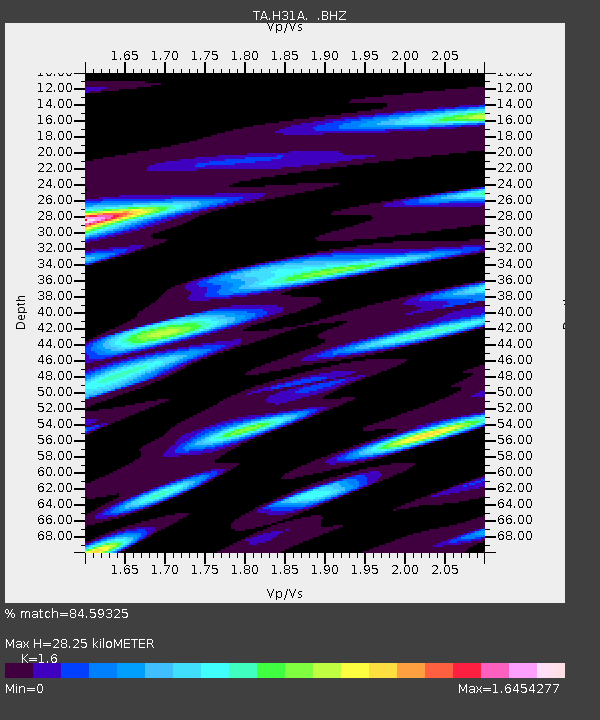
H31A Wolsey, SD, USA - Earthquake Result Viewer

Earthquake location: Near East Coast Of Honshu, Japan
Earthquake latitude/longitude: 37.7/141.7
Earthquake time(UTC): 2011/08/19 (231) 05:36:33 GMT
Earthquake Depth: 47 km
Earthquake Magnitude: 6.3 MB, 5.9 MS, 6.3 MW, 6.3 MW
Earthquake Catalog/Contributor: WHDF/NEIC
Network: TA USArray Transportable Network (new EarthScope stations)
Station: H31A Wolsey, SD, USA
Lat/Lon: 44.48 N/98.48 W
Elevation: 415 m
Distance: 81.8 deg
Az: 38.837 deg
Baz: 315.962 deg
Ray Param: 0.047226835
Estimated Moho Depth: 28.25 km
Estimated Crust Vp/Vs: 1.60
Assumed Crust Vp: 6.53 km/s
Estimated Crust Vs: 4.082 km/s
Estimated Crust Poisson's Ratio: 0.18
Radial Match: 84.59325 %
Radial Bump: 400
Transverse Match: 76.89678 %
Transverse Bump: 400
SOD ConfigId: 410809
Insert Time: 2012-01-06 09:24:57.576 +0000
GWidth: 2.5
Max Bumps: 400
Tol: 0.001

Signal To Noise

ChannelStoNSTALTA
TA:H31A: :BHZ:20110819T05:48:16.099998Z5.96836423.658112E-66.1291706E-7
TA:H31A: :BHN:20110819T05:48:16.099998Z4.001151.5376086E-63.8429164E-7
TA:H31A: :BHE:20110819T05:48:16.099998Z2.75465271.4624143E-65.3088877E-7
Arrivals
Ps2.7 SECOND
PpPs11 SECOND
PsPs/PpSs14 SECOND