You are here: Home > Network List > TA - USArray Transportable Network (new EarthScope stations) Stations List
> Station H35A Sunnyside Ranch, Fairfax, MN, USA > Earthquake Result Viewer
H35A Sunnyside Ranch, Fairfax, MN, USA - Earthquake Result Viewer

| Earthquake location: |
Near East Coast Of Honshu, Japan |
| Earthquake latitude/longitude: |
37.7/141.7 |
| Earthquake time(UTC): |
2011/08/19 (231) 05:36:33 GMT |
| Earthquake Depth: |
47 km |
| Earthquake Magnitude: |
6.3 MB, 5.9 MS, 6.3 MW, 6.3 MW |
| Earthquake Catalog/Contributor: |
WHDF/NEIC |
|
| Network: |
TA USArray Transportable Network (new EarthScope stations) |
| Station: |
H35A Sunnyside Ranch, Fairfax, MN, USA |
| Lat/Lon: |
44.70 N/94.83 W |
| Elevation: |
345 m |
|
| Distance: |
83.4 deg |
| Az: |
36.763 deg |
| Baz: |
318.247 deg |
| Ray Param: |
0.04610152 |
| Estimated Moho Depth: |
17.25 km |
| Estimated Crust Vp/Vs: |
2.06 |
| Assumed Crust Vp: |
6.571 km/s |
| Estimated Crust Vs: |
3.197 km/s |
| Estimated Crust Poisson's Ratio: |
0.34 |
|
| Radial Match: |
86.06791 % |
| Radial Bump: |
400 |
| Transverse Match: |
68.11725 % |
| Transverse Bump: |
400 |
| SOD ConfigId: |
410809 |
| Insert Time: |
2012-01-06 09:29:03.146 +0000 |
| GWidth: |
2.5 |
| Max Bumps: |
400 |
| Tol: |
0.001 |
|
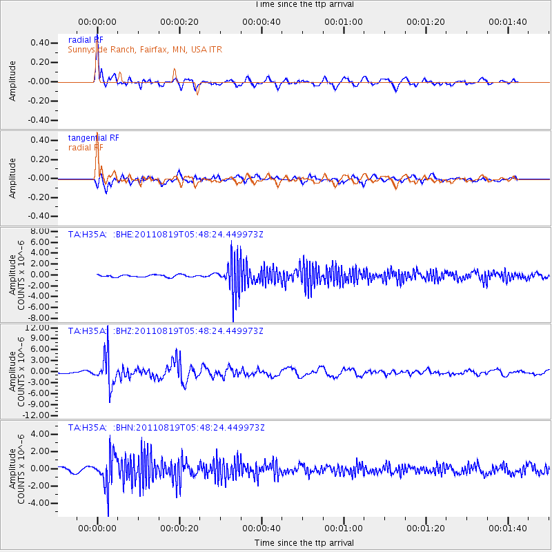
Signal To Noise
| Channel | StoN | STA | LTA |
| TA:H35A: :BHZ:20110819T05:48:24.449973Z | 8.517819 | 4.144811E-6 | 4.8660473E-7 |
| TA:H35A: :BHN:20110819T05:48:24.449973Z | 6.3350077 | 1.8042344E-6 | 2.8480383E-7 |
| TA:H35A: :BHE:20110819T05:48:24.449973Z | 14.5608225 | 2.9832777E-6 | 2.0488388E-7 |
| Arrivals |
| Ps | 2.8 SECOND |
| PpPs | 7.8 SECOND |
| PsPs/PpSs | 11 SECOND |


