You are here: Home > Network List > G - GEOSCOPE Stations List
> Station DRV Dumont d'Urville, Terre Adelie (Antartica) > Earthquake Result Viewer
DRV Dumont d'Urville, Terre Adelie (Antartica) - Earthquake Result Viewer
| Earthquake location: |
Mindanao, Philippines |
| Earthquake latitude/longitude: |
5.5/126.6 |
| Earthquake time(UTC): |
1999/06/18 (169) 10:55:25 GMT |
| Earthquake Depth: |
33 km |
| Earthquake Magnitude: |
6.1 MB, 6.1 MS, 6.4 MW, 6.4 MW |
| Earthquake Catalog/Contributor: |
WHDF/NEIC |
|
| Network: |
G GEOSCOPE |
| Station: |
DRV Dumont d'Urville, Terre Adelie (Antartica) |
| Lat/Lon: |
66.67 S/140.01 E |
| Elevation: |
40 m |
|
| Distance: |
72.6 deg |
| Az: |
174.462 deg |
| Baz: |
346.044 deg |
| Ray Param: |
0.05347414 |
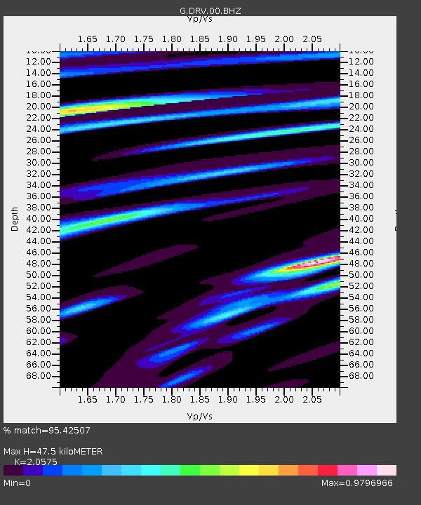
| Estimated Moho Depth: |
47.5 km |
| Estimated Crust Vp/Vs: |
2.06 |
| Assumed Crust Vp: |
6.39 km/s |
| Estimated Crust Vs: |
3.106 km/s |
| Estimated Crust Poisson's Ratio: |
0.35 |
|
| Radial Match: |
95.42507 % |
| Radial Bump: |
400 |
| Transverse Match: |
90.75035 % |
| Transverse Bump: |
400 |
| SOD ConfigId: |
4480 |
| Insert Time: |
2010-02-26 22:08:31.157 +0000 |
| GWidth: |
2.5 |
| Max Bumps: |
400 |
| Tol: |
0.001 |
|
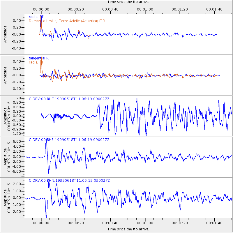
Signal To Noise
| Channel | StoN | STA | LTA |
| G:DRV:00:BHZ:19990618T11:06:19.090027Z | 18.95215 | 3.2097382E-6 | 1.693601E-7 |
| G:DRV:00:BHN:19990618T11:06:19.090027Z | 11.137125 | 1.2616418E-6 | 1.13282546E-7 |
| G:DRV:00:BHE:19990618T11:06:19.090027Z | 3.846076 | 4.1367093E-7 | 1.0755662E-7 |
| Arrivals |
| Ps | 8.1 SECOND |
| PpPs | 22 SECOND |
| PsPs/PpSs | 30 SECOND |


