You are here: Home > Network List > G - GEOSCOPE Stations List
> Station DRV Dumont d'Urville, Terre Adelie (Antartica) > Earthquake Result Viewer
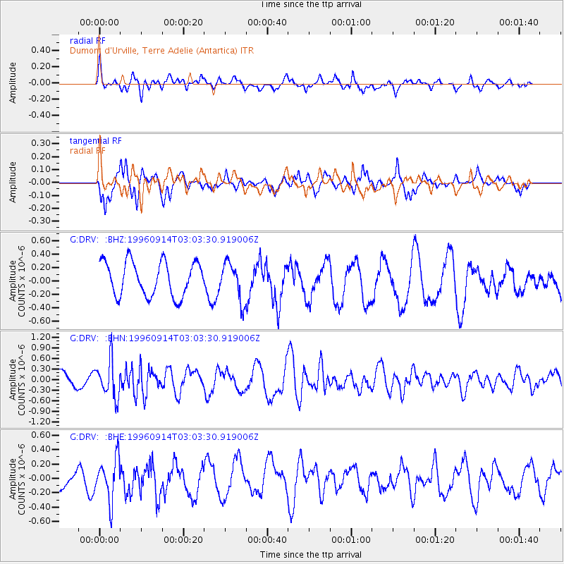
DRV Dumont d'Urville, Terre Adelie (Antartica) - Earthquake Result Viewer
*The percent match for this event was below the threshold and hence no stack was calculated.
| Earthquake location: |
Minahassa Peninsula, Sulawesi |
| Earthquake latitude/longitude: |
-0.0/122.8 |
| Earthquake time(UTC): |
1996/09/14 (258) 02:53:24 GMT |
| Earthquake Depth: |
181 km |
| Earthquake Magnitude: |
5.5 MB |
| Earthquake Catalog/Contributor: |
WHDF/NEIC |
|
| Network: |
G GEOSCOPE |
| Station: |
DRV Dumont d'Urville, Terre Adelie (Antartica) |
| Lat/Lon: |
66.67 S/140.01 E |
| Elevation: |
40 m |
|
| Distance: |
67.6 deg |
| Az: |
172.675 deg |
| Baz: |
341.334 deg |
| Ray Param: |
$rayparam |
*The percent match for this event was below the threshold and hence was not used in the summary stack. |
|
| Radial Match: |
70.135895 % |
| Radial Bump: |
400 |
| Transverse Match: |
67.90849 % |
| Transverse Bump: |
380 |
| SOD ConfigId: |
4480 |
| Insert Time: |
2010-02-26 22:08:32.835 +0000 |
| GWidth: |
2.5 |
| Max Bumps: |
400 |
| Tol: |
0.001 |
|
Signal To Noise
| Channel | StoN | STA | LTA |
| G:DRV: :BHN:19960914T03:03:30.919006Z | 1.8848753 | 5.306157E-7 | 2.8151234E-7 |
| G:DRV: :BHE:19960914T03:03:30.919006Z | 2.1119905 | 3.0091266E-7 | 1.4247823E-7 |
| G:DRV: :BHZ:19960914T03:03:30.919006Z | 1.1587937 | 2.9517645E-7 | 2.5472735E-7 |
| Arrivals |
| Ps | |
| PpPs | |
| PsPs/PpSs | |


