You are here: Home > Network List > TA - USArray Transportable Network (new EarthScope stations) Stations List
> Station S40A Lebanon, MO, USA > Earthquake Result Viewer
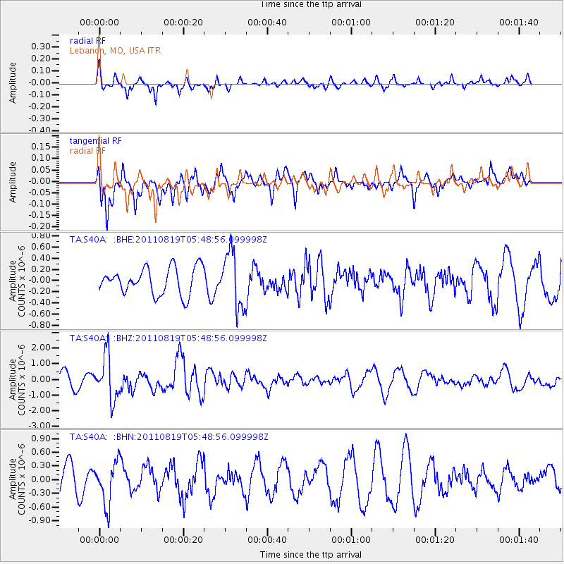
S40A Lebanon, MO, USA - Earthquake Result Viewer
*The percent match for this event was below the threshold and hence no stack was calculated.
| Earthquake location: |
Near East Coast Of Honshu, Japan |
| Earthquake latitude/longitude: |
37.7/141.7 |
| Earthquake time(UTC): |
2011/08/19 (231) 05:36:33 GMT |
| Earthquake Depth: |
47 km |
| Earthquake Magnitude: |
6.3 MB, 5.9 MS, 6.3 MW, 6.3 MW |
| Earthquake Catalog/Contributor: |
WHDF/NEIC |
|
| Network: |
TA USArray Transportable Network (new EarthScope stations) |
| Station: |
S40A Lebanon, MO, USA |
| Lat/Lon: |
37.60 N/92.50 W |
| Elevation: |
336 m |
|
| Distance: |
90.0 deg |
| Az: |
40.078 deg |
| Baz: |
319.968 deg |
| Ray Param: |
$rayparam |
*The percent match for this event was below the threshold and hence was not used in the summary stack. |
|
| Radial Match: |
39.604343 % |
| Radial Bump: |
279 |
| Transverse Match: |
64.52375 % |
| Transverse Bump: |
400 |
| SOD ConfigId: |
410809 |
| Insert Time: |
2012-01-06 09:33:36.236 +0000 |
| GWidth: |
2.5 |
| Max Bumps: |
400 |
| Tol: |
0.001 |
|
Signal To Noise
| Channel | StoN | STA | LTA |
| TA:S40A: :BHZ:20110819T05:48:56.099998Z | 3.4730513 | 1.4590217E-6 | 4.2009793E-7 |
| TA:S40A: :BHN:20110819T05:48:56.099998Z | 1.4947052 | 4.7980734E-7 | 3.2100465E-7 |
| TA:S40A: :BHE:20110819T05:48:56.099998Z | 2.1276605 | 5.072422E-7 | 2.3840371E-7 |
| Arrivals |
| Ps | |
| PpPs | |
| PsPs/PpSs | |


