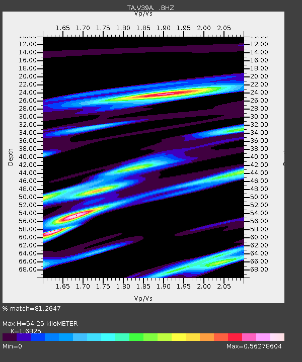
V39A Pettigrew, AR, USA - Earthquake Result Viewer

Earthquake location: Near East Coast Of Honshu, Japan
Earthquake latitude/longitude: 37.7/141.7
Earthquake time(UTC): 2011/08/19 (231) 05:36:33 GMT
Earthquake Depth: 47 km
Earthquake Magnitude: 6.3 MB, 5.9 MS, 6.3 MW, 6.3 MW
Earthquake Catalog/Contributor: WHDF/NEIC
Network: TA USArray Transportable Network (new EarthScope stations)
Station: V39A Pettigrew, AR, USA
Lat/Lon: 35.84 N/93.64 W
Elevation: 744 m
Distance: 90.7 deg
Az: 41.916 deg
Baz: 319.277 deg
Ray Param: 0.041647114
Estimated Moho Depth: 54.25 km
Estimated Crust Vp/Vs: 1.68
Assumed Crust Vp: 6.498 km/s
Estimated Crust Vs: 3.862 km/s
Estimated Crust Poisson's Ratio: 0.23
Radial Match: 81.2647 %
Radial Bump: 400
Transverse Match: 80.55891 %
Transverse Bump: 400
SOD ConfigId: 410809
Insert Time: 2012-01-06 09:35:07.350 +0000
GWidth: 2.5
Max Bumps: 400
Tol: 0.001

Signal To Noise

ChannelStoNSTALTA
TA:V39A: :BHZ:20110819T05:48:59.55001Z3.45615031.5605134E-64.515178E-7
TA:V39A: :BHN:20110819T05:48:59.55001Z1.95175245.997249E-73.072751E-7
TA:V39A: :BHE:20110819T05:48:59.55001Z2.2245595.7145456E-72.5688442E-7
Arrivals
Ps5.8 SECOND
PpPs22 SECOND
PsPs/PpSs28 SECOND