You are here: Home > Network List > TA - USArray Transportable Network (new EarthScope stations) Stations List
> Station 243A Waterproof, LA, USA > Earthquake Result Viewer
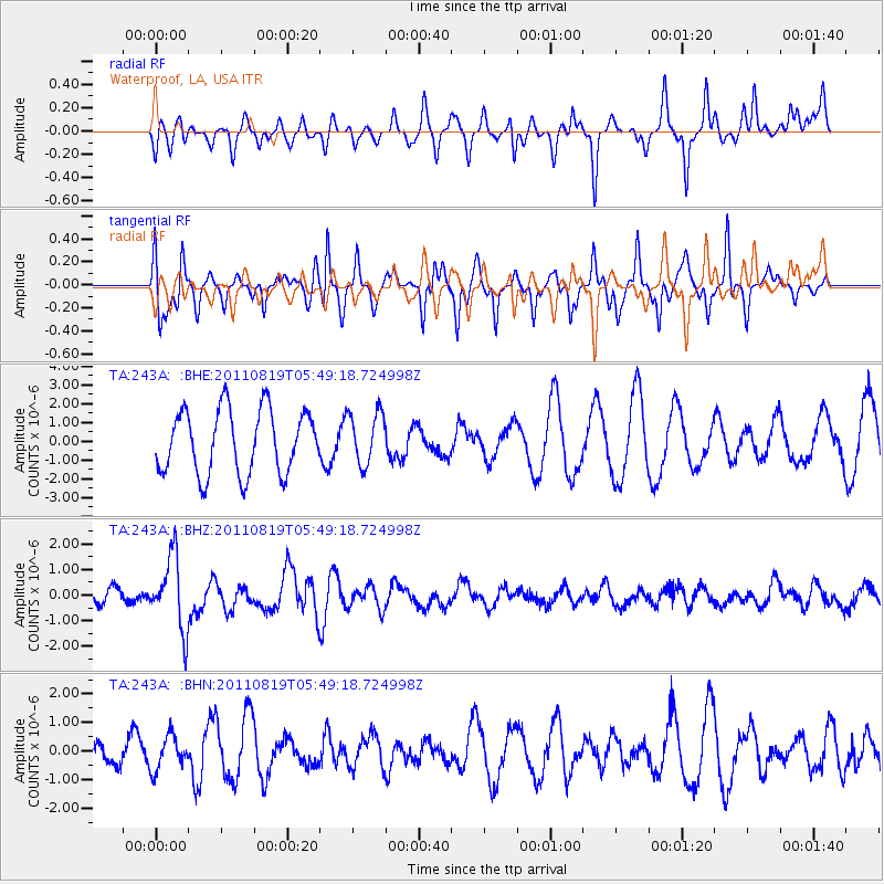
243A Waterproof, LA, USA - Earthquake Result Viewer
*The percent match for this event was below the threshold and hence no stack was calculated.
| Earthquake location: |
Near East Coast Of Honshu, Japan |
| Earthquake latitude/longitude: |
37.7/141.7 |
| Earthquake time(UTC): |
2011/08/19 (231) 05:36:33 GMT |
| Earthquake Depth: |
47 km |
| Earthquake Magnitude: |
6.3 MB, 5.9 MS, 6.3 MW, 6.3 MW |
| Earthquake Catalog/Contributor: |
WHDF/NEIC |
|
| Network: |
TA USArray Transportable Network (new EarthScope stations) |
| Station: |
243A Waterproof, LA, USA |
| Lat/Lon: |
31.88 N/91.48 W |
| Elevation: |
2.0 m |
|
| Distance: |
94.9 deg |
| Az: |
43.087 deg |
| Baz: |
320.419 deg |
| Ray Param: |
$rayparam |
*The percent match for this event was below the threshold and hence was not used in the summary stack. |
|
| Radial Match: |
49.480804 % |
| Radial Bump: |
247 |
| Transverse Match: |
73.06041 % |
| Transverse Bump: |
312 |
| SOD ConfigId: |
410809 |
| Insert Time: |
2012-01-06 09:35:55.169 +0000 |
| GWidth: |
2.5 |
| Max Bumps: |
400 |
| Tol: |
0.001 |
|
Signal To Noise
| Channel | StoN | STA | LTA |
| TA:243A: :BHZ:20110819T05:49:18.724998Z | 2.651505 | 1.4063586E-6 | 5.3040014E-7 |
| TA:243A: :BHN:20110819T05:49:18.724998Z | 1.0987726 | 5.8663534E-7 | 5.339006E-7 |
| TA:243A: :BHE:20110819T05:49:18.724998Z | 0.8265806 | 1.4036551E-6 | 1.6981468E-6 |
| Arrivals |
| Ps | |
| PpPs | |
| PsPs/PpSs | |


