You are here: Home > Network List > TA - USArray Transportable Network (new EarthScope stations) Stations List
> Station 244A Avery, Jackson, MS, USA > Earthquake Result Viewer
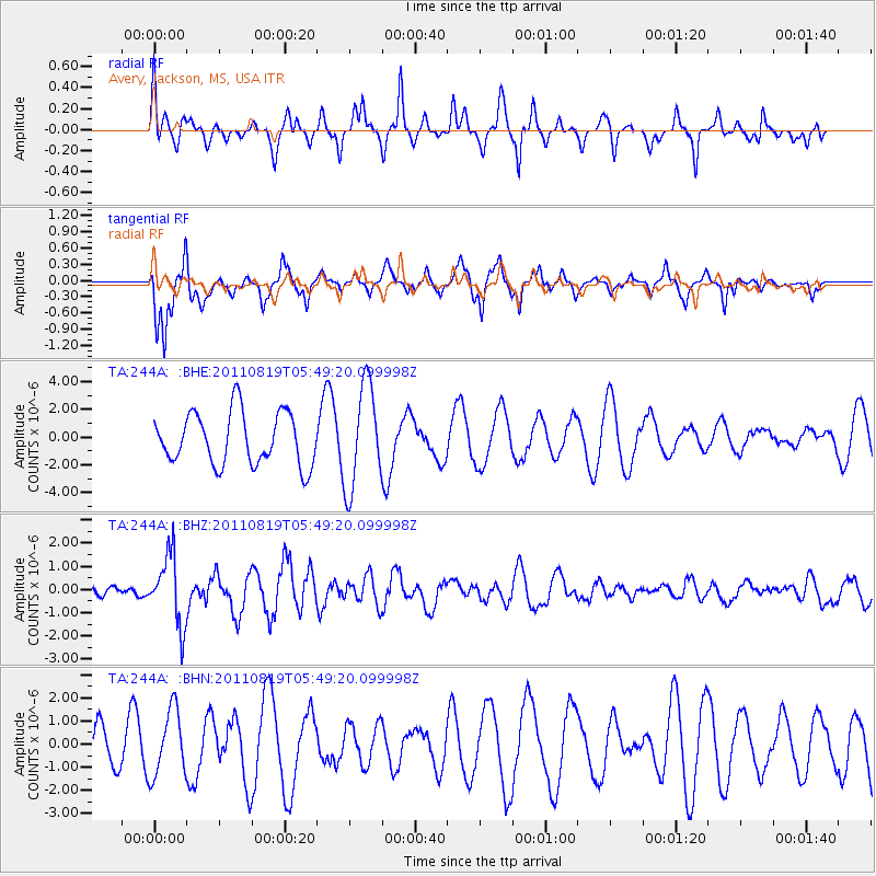
244A Avery, Jackson, MS, USA - Earthquake Result Viewer
*The percent match for this event was below the threshold and hence no stack was calculated.
| Earthquake location: |
Near East Coast Of Honshu, Japan |
| Earthquake latitude/longitude: |
37.7/141.7 |
| Earthquake time(UTC): |
2011/08/19 (231) 05:36:33 GMT |
| Earthquake Depth: |
47 km |
| Earthquake Magnitude: |
6.3 MB, 5.9 MS, 6.3 MW, 6.3 MW |
| Earthquake Catalog/Contributor: |
WHDF/NEIC |
|
| Network: |
TA USArray Transportable Network (new EarthScope stations) |
| Station: |
244A Avery, Jackson, MS, USA |
| Lat/Lon: |
32.04 N/90.69 W |
| Elevation: |
59 m |
|
| Distance: |
95.2 deg |
| Az: |
42.459 deg |
| Baz: |
320.895 deg |
| Ray Param: |
$rayparam |
*The percent match for this event was below the threshold and hence was not used in the summary stack. |
|
| Radial Match: |
34.12792 % |
| Radial Bump: |
279 |
| Transverse Match: |
54.78477 % |
| Transverse Bump: |
306 |
| SOD ConfigId: |
410809 |
| Insert Time: |
2012-01-06 09:37:29.883 +0000 |
| GWidth: |
2.5 |
| Max Bumps: |
400 |
| Tol: |
0.001 |
|
Signal To Noise
| Channel | StoN | STA | LTA |
| TA:244A: :BHZ:20110819T05:49:20.099998Z | 5.0192704 | 1.4979578E-6 | 2.9844134E-7 |
| TA:244A: :BHN:20110819T05:49:20.099998Z | 1.4504867 | 1.4219751E-6 | 9.803434E-7 |
| TA:244A: :BHE:20110819T05:49:20.099998Z | 1.9818257 | 3.7139541E-6 | 1.8740063E-6 |
| Arrivals |
| Ps | |
| PpPs | |
| PsPs/PpSs | |


