You are here: Home > Network List > TA - USArray Transportable Network (new EarthScope stations) Stations List
> Station Y43A Makayla and Karen, Gunnison, MS, USA > Earthquake Result Viewer
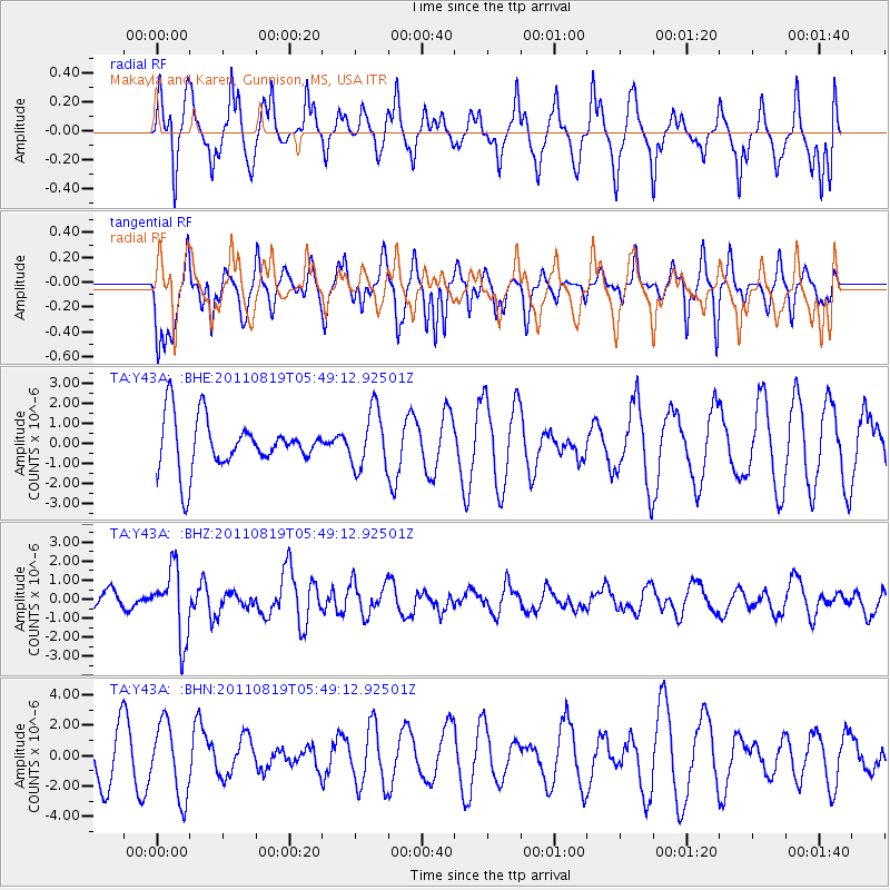
Y43A Makayla and Karen, Gunnison, MS, USA - Earthquake Result Viewer
*The percent match for this event was below the threshold and hence no stack was calculated.
| Earthquake location: |
Near East Coast Of Honshu, Japan |
| Earthquake latitude/longitude: |
37.7/141.7 |
| Earthquake time(UTC): |
2011/08/19 (231) 05:36:33 GMT |
| Earthquake Depth: |
47 km |
| Earthquake Magnitude: |
6.3 MB, 5.9 MS, 6.3 MW, 6.3 MW |
| Earthquake Catalog/Contributor: |
WHDF/NEIC |
|
| Network: |
TA USArray Transportable Network (new EarthScope stations) |
| Station: |
Y43A Makayla and Karen, Gunnison, MS, USA |
| Lat/Lon: |
33.91 N/90.93 W |
| Elevation: |
46 m |
|
| Distance: |
93.6 deg |
| Az: |
41.437 deg |
| Baz: |
320.841 deg |
| Ray Param: |
$rayparam |
*The percent match for this event was below the threshold and hence was not used in the summary stack. |
|
| Radial Match: |
57.51412 % |
| Radial Bump: |
375 |
| Transverse Match: |
64.87098 % |
| Transverse Bump: |
350 |
| SOD ConfigId: |
410809 |
| Insert Time: |
2012-01-06 09:39:16.317 +0000 |
| GWidth: |
2.5 |
| Max Bumps: |
400 |
| Tol: |
0.001 |
|
Signal To Noise
| Channel | StoN | STA | LTA |
| TA:Y43A: :BHZ:20110819T05:49:12.92501Z | 4.325746 | 1.8096597E-6 | 4.1834625E-7 |
| TA:Y43A: :BHN:20110819T05:49:12.92501Z | 1.3938708 | 2.4135998E-6 | 1.7315806E-6 |
| TA:Y43A: :BHE:20110819T05:49:12.92501Z | 1.1660774 | 1.4531618E-6 | 1.2461967E-6 |
| Arrivals |
| Ps | |
| PpPs | |
| PsPs/PpSs | |


