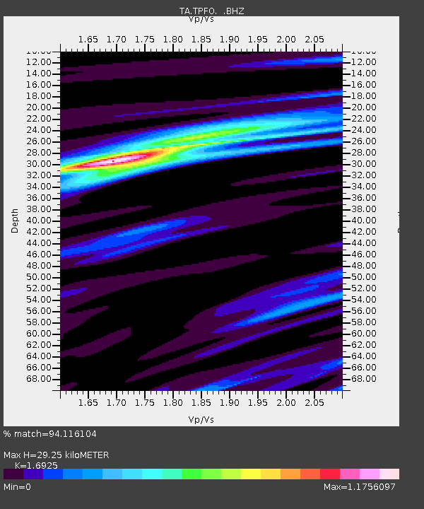
TPFO Pinon Flats, CA, USA - Earthquake Result Viewer
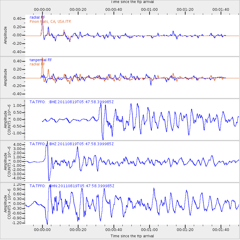
Earthquake location: Near East Coast Of Honshu, Japan
Earthquake latitude/longitude: 37.7/141.7
Earthquake time(UTC): 2011/08/19 (231) 05:36:33 GMT
Earthquake Depth: 47 km
Earthquake Magnitude: 6.3 MB, 5.9 MS, 6.3 MW, 6.3 MW
Earthquake Catalog/Contributor: WHDF/NEIC
Network: TA USArray Transportable Network (new EarthScope stations)
Station: TPFO Pinon Flats, CA, USA
Lat/Lon: 33.61 N/116.45 W
Elevation: 1275 m
Distance: 78.5 deg
Az: 56.437 deg
Baz: 307.6 deg
Ray Param: 0.049493358
Estimated Moho Depth: 29.25 km
Estimated Crust Vp/Vs: 1.69
Assumed Crust Vp: 6.264 km/s
Estimated Crust Vs: 3.701 km/s
Estimated Crust Poisson's Ratio: 0.23
Radial Match: 94.116104 %
Radial Bump: 286
Transverse Match: 85.95182 %
Transverse Bump: 372
SOD ConfigId: 410809
Insert Time: 2012-01-06 09:40:21.630 +0000
GWidth: 2.5
Max Bumps: 400
Tol: 0.001

Signal To Noise

ChannelStoNSTALTA
TA:TPFO: :BHZ:20110819T05:47:58.399985Z25.6102392.6133478E-61.0204309E-7
TA:TPFO: :BHN:20110819T05:47:58.399985Z7.0309627.114618E-71.0118982E-7
TA:TPFO: :BHE:20110819T05:47:58.399985Z8.9378456.769439E-77.5739045E-8
Arrivals
Ps3.3 SECOND
PpPs12 SECOND
PsPs/PpSs16 SECOND