You are here: Home > Network List > TA - USArray Transportable Network (new EarthScope stations) Stations List
> Station S43A Fulton Ridge, Patton, MO, USA > Earthquake Result Viewer
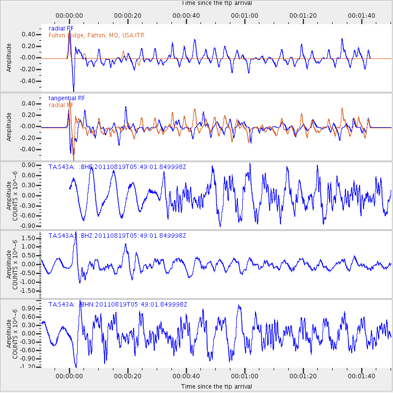
S43A Fulton Ridge, Patton, MO, USA - Earthquake Result Viewer
*The percent match for this event was below the threshold and hence no stack was calculated.
| Earthquake location: |
Near East Coast Of Honshu, Japan |
| Earthquake latitude/longitude: |
37.7/141.7 |
| Earthquake time(UTC): |
2011/08/19 (231) 05:36:33 GMT |
| Earthquake Depth: |
47 km |
| Earthquake Magnitude: |
6.3 MB, 5.9 MS, 6.3 MW, 6.3 MW |
| Earthquake Catalog/Contributor: |
WHDF/NEIC |
|
| Network: |
TA USArray Transportable Network (new EarthScope stations) |
| Station: |
S43A Fulton Ridge, Patton, MO, USA |
| Lat/Lon: |
37.57 N/90.08 W |
| Elevation: |
263 m |
|
| Distance: |
91.2 deg |
| Az: |
38.604 deg |
| Baz: |
321.457 deg |
| Ray Param: |
$rayparam |
*The percent match for this event was below the threshold and hence was not used in the summary stack. |
|
| Radial Match: |
62.529263 % |
| Radial Bump: |
371 |
| Transverse Match: |
73.13641 % |
| Transverse Bump: |
400 |
| SOD ConfigId: |
410809 |
| Insert Time: |
2012-01-06 09:42:19.396 +0000 |
| GWidth: |
2.5 |
| Max Bumps: |
400 |
| Tol: |
0.001 |
|
Signal To Noise
| Channel | StoN | STA | LTA |
| TA:S43A: :BHZ:20110819T05:49:01.849998Z | 2.0067933 | 7.7825064E-7 | 3.8780806E-7 |
| TA:S43A: :BHN:20110819T05:49:01.849998Z | 1.2874348 | 6.247015E-7 | 4.852296E-7 |
| TA:S43A: :BHE:20110819T05:49:01.849998Z | 0.73549265 | 3.1307977E-7 | 4.2567353E-7 |
| Arrivals |
| Ps | |
| PpPs | |
| PsPs/PpSs | |


