You are here: Home > Network List > TA - USArray Transportable Network (new EarthScope stations) Stations List
> Station S44A Carbondale, IL, USA > Earthquake Result Viewer
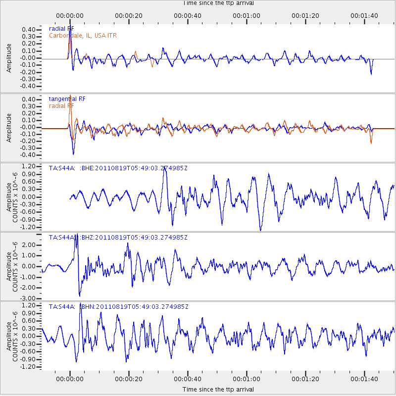
S44A Carbondale, IL, USA - Earthquake Result Viewer
*The percent match for this event was below the threshold and hence no stack was calculated.
| Earthquake location: |
Near East Coast Of Honshu, Japan |
| Earthquake latitude/longitude: |
37.7/141.7 |
| Earthquake time(UTC): |
2011/08/19 (231) 05:36:33 GMT |
| Earthquake Depth: |
47 km |
| Earthquake Magnitude: |
6.3 MB, 5.9 MS, 6.3 MW, 6.3 MW |
| Earthquake Catalog/Contributor: |
WHDF/NEIC |
|
| Network: |
TA USArray Transportable Network (new EarthScope stations) |
| Station: |
S44A Carbondale, IL, USA |
| Lat/Lon: |
37.69 N/89.26 W |
| Elevation: |
155 m |
|
| Distance: |
91.5 deg |
| Az: |
38.017 deg |
| Baz: |
321.97 deg |
| Ray Param: |
$rayparam |
*The percent match for this event was below the threshold and hence was not used in the summary stack. |
|
| Radial Match: |
72.94894 % |
| Radial Bump: |
400 |
| Transverse Match: |
73.366554 % |
| Transverse Bump: |
400 |
| SOD ConfigId: |
410809 |
| Insert Time: |
2012-01-06 09:42:35.680 +0000 |
| GWidth: |
2.5 |
| Max Bumps: |
400 |
| Tol: |
0.001 |
|
Signal To Noise
| Channel | StoN | STA | LTA |
| TA:S44A: :BHZ:20110819T05:49:03.274985Z | 7.1874995 | 1.5984706E-6 | 2.2239594E-7 |
| TA:S44A: :BHN:20110819T05:49:03.274985Z | 1.8962872 | 5.737954E-7 | 3.0258886E-7 |
| TA:S44A: :BHE:20110819T05:49:03.274985Z | 3.1917148 | 6.348636E-7 | 1.9890987E-7 |
| Arrivals |
| Ps | |
| PpPs | |
| PsPs/PpSs | |


