You are here: Home > Network List > TA - USArray Transportable Network (new EarthScope stations) Stations List
> Station W42A Bald Knob, AR, USA > Earthquake Result Viewer
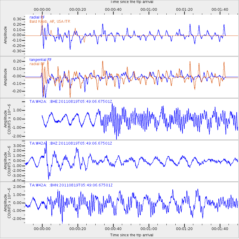
W42A Bald Knob, AR, USA - Earthquake Result Viewer
*The percent match for this event was below the threshold and hence no stack was calculated.
| Earthquake location: |
Near East Coast Of Honshu, Japan |
| Earthquake latitude/longitude: |
37.7/141.7 |
| Earthquake time(UTC): |
2011/08/19 (231) 05:36:33 GMT |
| Earthquake Depth: |
47 km |
| Earthquake Magnitude: |
6.3 MB, 5.9 MS, 6.3 MW, 6.3 MW |
| Earthquake Catalog/Contributor: |
WHDF/NEIC |
|
| Network: |
TA USArray Transportable Network (new EarthScope stations) |
| Station: |
W42A Bald Knob, AR, USA |
| Lat/Lon: |
35.27 N/91.52 W |
| Elevation: |
71 m |
|
| Distance: |
92.3 deg |
| Az: |
40.955 deg |
| Baz: |
320.53 deg |
| Ray Param: |
$rayparam |
*The percent match for this event was below the threshold and hence was not used in the summary stack. |
|
| Radial Match: |
72.924675 % |
| Radial Bump: |
400 |
| Transverse Match: |
64.952225 % |
| Transverse Bump: |
400 |
| SOD ConfigId: |
410809 |
| Insert Time: |
2012-01-06 09:45:47.017 +0000 |
| GWidth: |
2.5 |
| Max Bumps: |
400 |
| Tol: |
0.001 |
|
Signal To Noise
| Channel | StoN | STA | LTA |
| TA:W42A: :BHZ:20110819T05:49:06.67501Z | 6.2669044 | 1.9512174E-6 | 3.1135266E-7 |
| TA:W42A: :BHN:20110819T05:49:06.67501Z | 1.3964465 | 3.596283E-7 | 2.5753104E-7 |
| TA:W42A: :BHE:20110819T05:49:06.67501Z | 1.5589914 | 6.6060414E-7 | 4.2373813E-7 |
| Arrivals |
| Ps | |
| PpPs | |
| PsPs/PpSs | |


