You are here: Home > Network List > TA - USArray Transportable Network (new EarthScope stations) Stations List
> Station U44B Burton Farm, Hornbeak, TN, USA > Earthquake Result Viewer
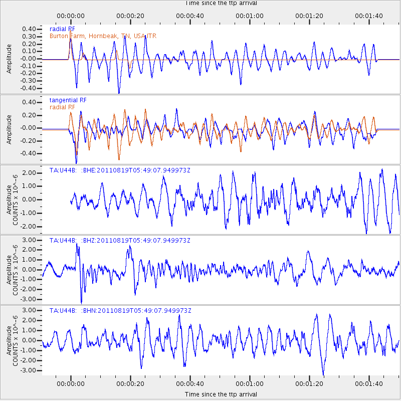
U44B Burton Farm, Hornbeak, TN, USA - Earthquake Result Viewer
*The percent match for this event was below the threshold and hence no stack was calculated.
| Earthquake location: |
Near East Coast Of Honshu, Japan |
| Earthquake latitude/longitude: |
37.7/141.7 |
| Earthquake time(UTC): |
2011/08/19 (231) 05:36:33 GMT |
| Earthquake Depth: |
47 km |
| Earthquake Magnitude: |
6.3 MB, 5.9 MS, 6.3 MW, 6.3 MW |
| Earthquake Catalog/Contributor: |
WHDF/NEIC |
|
| Network: |
TA USArray Transportable Network (new EarthScope stations) |
| Station: |
U44B Burton Farm, Hornbeak, TN, USA |
| Lat/Lon: |
36.34 N/89.35 W |
| Elevation: |
136 m |
|
| Distance: |
92.5 deg |
| Az: |
38.911 deg |
| Baz: |
321.881 deg |
| Ray Param: |
$rayparam |
*The percent match for this event was below the threshold and hence was not used in the summary stack. |
|
| Radial Match: |
63.84938 % |
| Radial Bump: |
400 |
| Transverse Match: |
61.82648 % |
| Transverse Bump: |
400 |
| SOD ConfigId: |
410809 |
| Insert Time: |
2012-01-06 09:46:35.087 +0000 |
| GWidth: |
2.5 |
| Max Bumps: |
400 |
| Tol: |
0.001 |
|
Signal To Noise
| Channel | StoN | STA | LTA |
| TA:U44B: :BHZ:20110819T05:49:07.949973Z | 3.396228 | 1.4294827E-6 | 4.2090304E-7 |
| TA:U44B: :BHN:20110819T05:49:07.949973Z | 1.2761984 | 9.4494897E-7 | 7.4044044E-7 |
| TA:U44B: :BHE:20110819T05:49:07.949973Z | 2.0032125 | 1.0734879E-6 | 5.3588315E-7 |
| Arrivals |
| Ps | |
| PpPs | |
| PsPs/PpSs | |


