You are here: Home > Network List > UW - Pacific Northwest Regional Seismic Network Stations List
> Station HEBO Mt. Hebo, OR CREST BB SMO > Earthquake Result Viewer
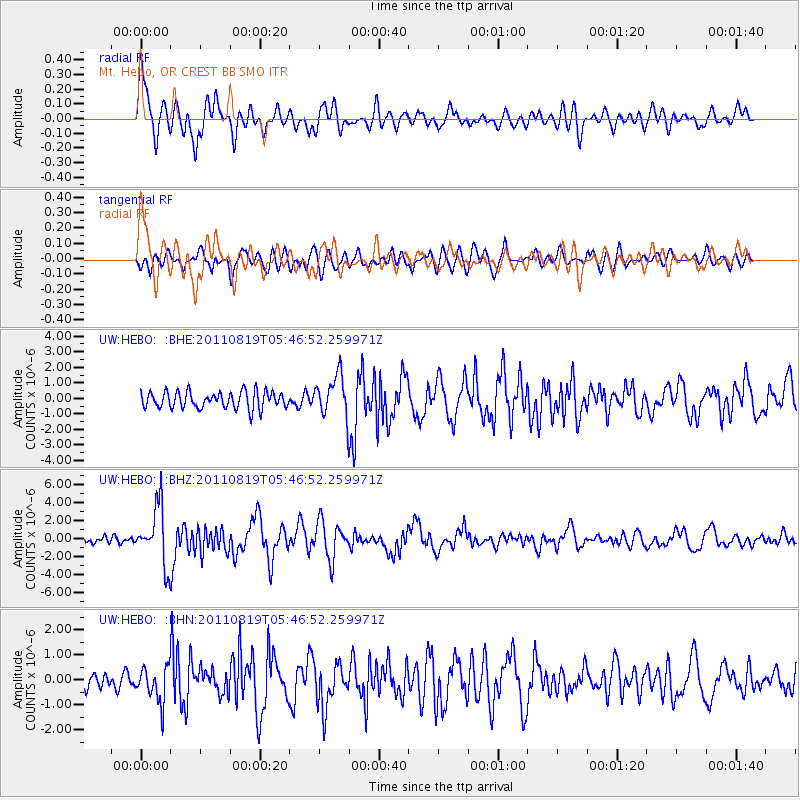
HEBO Mt. Hebo, OR CREST BB SMO - Earthquake Result Viewer
*The percent match for this event was below the threshold and hence no stack was calculated.
| Earthquake location: |
Near East Coast Of Honshu, Japan |
| Earthquake latitude/longitude: |
37.7/141.7 |
| Earthquake time(UTC): |
2011/08/19 (231) 05:36:33 GMT |
| Earthquake Depth: |
47 km |
| Earthquake Magnitude: |
6.3 MB, 5.9 MS, 6.3 MW, 6.3 MW |
| Earthquake Catalog/Contributor: |
WHDF/NEIC |
|
| Network: |
UW Pacific Northwest Regional Seismic Network |
| Station: |
HEBO Mt. Hebo, OR CREST BB SMO |
| Lat/Lon: |
45.21 N/123.76 W |
| Elevation: |
875 m |
|
| Distance: |
67.3 deg |
| Az: |
49.784 deg |
| Baz: |
300.991 deg |
| Ray Param: |
$rayparam |
*The percent match for this event was below the threshold and hence was not used in the summary stack. |
|
| Radial Match: |
78.88138 % |
| Radial Bump: |
400 |
| Transverse Match: |
65.84565 % |
| Transverse Bump: |
400 |
| SOD ConfigId: |
410809 |
| Insert Time: |
2012-01-06 09:50:44.411 +0000 |
| GWidth: |
2.5 |
| Max Bumps: |
400 |
| Tol: |
0.001 |
|
Signal To Noise
| Channel | StoN | STA | LTA |
| UW:HEBO: :BHZ:20110819T05:46:52.259971Z | 8.473956 | 3.214801E-6 | 3.7937426E-7 |
| UW:HEBO: :BHN:20110819T05:46:52.259971Z | 1.866895 | 7.010667E-7 | 3.7552553E-7 |
| UW:HEBO: :BHE:20110819T05:46:52.259971Z | 2.5313487 | 1.3543643E-6 | 5.3503663E-7 |
| Arrivals |
| Ps | |
| PpPs | |
| PsPs/PpSs | |


