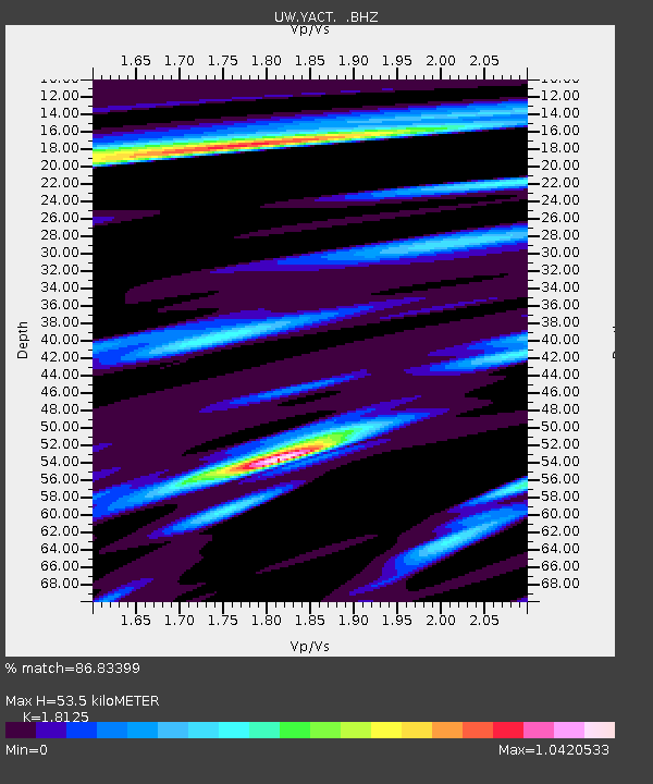
YACT Amboy, WA, USA - Earthquake Result Viewer

Earthquake location: Near East Coast Of Honshu, Japan
Earthquake latitude/longitude: 37.7/141.7
Earthquake time(UTC): 2011/08/19 (231) 05:36:33 GMT
Earthquake Depth: 47 km
Earthquake Magnitude: 6.3 MB, 5.9 MS, 6.3 MW, 6.3 MW
Earthquake Catalog/Contributor: WHDF/NEIC
Network: UW Pacific Northwest Regional Seismic Network
Station: YACT Amboy, WA, USA
Lat/Lon: 45.93 N/122.42 W
Elevation: 211 m
Distance: 67.8 deg
Az: 48.592 deg
Baz: 301.487 deg
Ray Param: 0.05666021
Estimated Moho Depth: 53.5 km
Estimated Crust Vp/Vs: 1.81
Assumed Crust Vp: 6.566 km/s
Estimated Crust Vs: 3.623 km/s
Estimated Crust Poisson's Ratio: 0.28
Radial Match: 86.83399 %
Radial Bump: 400
Transverse Match: 72.20036 %
Transverse Bump: 400
SOD ConfigId: 410809
Insert Time: 2012-01-06 09:50:52.401 +0000
GWidth: 2.5
Max Bumps: 400
Tol: 0.001

Signal To Noise

ChannelStoNSTALTA
UW:YACT: :BHZ:20110819T05:46:54.949973Z23.8900812.8653492E-61.1993886E-7
UW:YACT: :BHN:20110819T05:46:54.949973Z4.02316244.8950574E-71.2167187E-7
UW:YACT: :BHE:20110819T05:46:54.949973Z9.50523958.657806E-79.108456E-8
Arrivals
Ps6.9 SECOND
PpPs22 SECOND
PsPs/PpSs29 SECOND