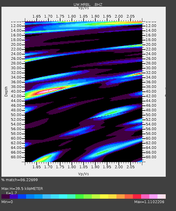
MRBL Marblemount, WA, USA - Earthquake Result Viewer
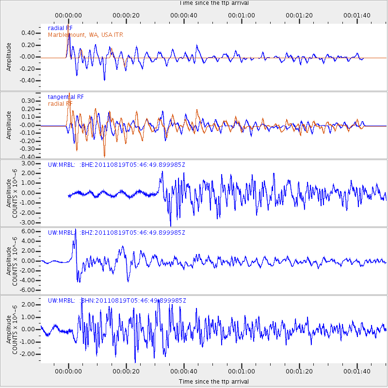
Earthquake location: Near East Coast Of Honshu, Japan
Earthquake latitude/longitude: 37.7/141.7
Earthquake time(UTC): 2011/08/19 (231) 05:36:33 GMT
Earthquake Depth: 47 km
Earthquake Magnitude: 6.3 MB, 5.9 MS, 6.3 MW, 6.3 MW
Earthquake Catalog/Contributor: WHDF/NEIC
Network: UW Pacific Northwest Regional Seismic Network
Station: MRBL Marblemount, WA, USA
Lat/Lon: 48.52 N/121.48 W
Elevation: 75 m
Distance: 67.0 deg
Az: 45.838 deg
Baz: 301.111 deg
Ray Param: 0.05718045
Estimated Moho Depth: 39.5 km
Estimated Crust Vp/Vs: 1.70
Assumed Crust Vp: 6.566 km/s
Estimated Crust Vs: 3.862 km/s
Estimated Crust Poisson's Ratio: 0.24
Radial Match: 86.22699 %
Radial Bump: 400
Transverse Match: 76.04531 %
Transverse Bump: 400
SOD ConfigId: 410809
Insert Time: 2012-01-06 09:50:59.081 +0000
GWidth: 2.5
Max Bumps: 400
Tol: 0.001

Signal To Noise

ChannelStoNSTALTA
UW:MRBL: :BHZ:20110819T05:46:49.899985Z18.696092.7873903E-61.4908947E-7
UW:MRBL: :BHN:20110819T05:46:49.899985Z4.4445338.2539214E-71.8570952E-7
UW:MRBL: :BHE:20110819T05:46:49.899985Z5.1638939.506486E-71.8409533E-7
Arrivals
Ps4.4 SECOND
PpPs16 SECOND
PsPs/PpSs20 SECOND